Gokyo Lake Trek – The Khumbu’s Best Kept Secret
Most people who go to the Khumbu head for Everest Base Camp. That’s fine. It’s an excellent trek. But if you’re willing to branch off the main trail at Namche Bazaar and walk a few days north through the Gokyo Valley, you’ll find something the standard EBC route simply doesn’t have: a chain of turquoise glacial lakes sitting at over 4,700 metres, one of the finest mountain viewpoints in all of Nepal, and a trail quiet enough that you’ll sometimes go an hour without passing another trekker.
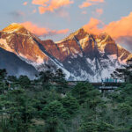
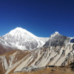
The Gokyo Lake Trek centres on the Gokyo Valley, a remote side valley of the Khumbu that most EBC trekkers walk right past. The valley holds six glacial lakes, the longest glacier in Nepal (the Ngozumpa Glacier), and the summit of Gokyo Ri at 5,357 m, from which you can see four of the world’s fourteen 8,000-metre peaks simultaneously: Everest, Lhotse, Makalu, and Cho Oyu. Many experienced trekkers and photographers consider this the best panoramic Everest viewpoint in the entire region, better than Kala Patthar.
The standard 12-day itinerary suits most trekkers well. Those with more time can extend it to 14 days to include a crossing of the Renjo La Pass at 5,360 m — one of the most dramatic high passes in the Everest region — before looping back to Namche via the Thame Valley. Either way, the Gokyo Lake Trek is the Khumbu’s most rewarding alternative to the classic EBC route.
Trek at a Glance
| Duration | 12 Days (standard) / 14–16 Days (with Renjo La Pass) |
| Maximum Altitude | 5,357 m / 17,575 ft (Gokyo Ri) — 5,360 m with Renjo La Pass |
| Trek Start / End | Lukla (2,860 m) — fly from Kathmandu |
| Difficulty | Moderate to Challenging — prior trekking experience recommended |
| Daily Walking | 5–8 hours per day |
| Best Seasons | March–May and October–November |
| Accommodation | Teahouses along the trail; best range in Namche and Gokyo |
| Permits Required | Sagarmatha National Park + Khumbu Pasang Lhamu Rural Municipality |
| Cost (approximate) | USD $1,000–$2,000 depending on operator, route, and group size |
| Trek Distance | Approximately 130–160 km round trip depending on route |
Day-by-Day Itinerary (Standard 12-Day Route)
The itinerary below covers the standard Gokyo Lake Trek without the Renjo La Pass extension. Day 13–14 extension notes are included after the main itinerary for those who want the full circuit.
| Day | Route | Altitude | Walking Time |
| Day 1 | Kathmandu → Lukla → Phakding | 2,610 m | 3–4 hrs |
| Day 2 | Phakding → Namche Bazaar | 3,440 m | 5–6 hrs |
| Day 3 | Acclimatisation — Namche Bazaar / Everest View Hotel hike | 3,880 m (hike) | 3–4 hrs |
| Day 4 | Namche Bazaar → Dole | 4,040 m | 5–6 hrs |
| Day 5 | Dole → Machhermo | 4,470 m | 4–5 hrs |
| Day 6 | Machhermo → Gokyo | 4,790 m | 4–5 hrs |
| Day 7 | Acclimatisation — Gokyo Ri summit (5,357 m) + lake exploration | 5,357 m (hike) | 5–6 hrs |
| Day 8 | Optional: 4th & 5th Lakes excursion or rest at Gokyo | ~5,000 m | 3–5 hrs |
| Day 9 | Gokyo → Dole | 4,040 m | 4–5 hrs |
| Day 10 | Dole → Namche Bazaar | 3,440 m | 5–6 hrs |
| Day 11 | Namche Bazaar → Lukla | 2,860 m | 6–7 hrs |
| Day 12 | Lukla → Kathmandu (flight) | 1,400 m | 35 min flight |
Day 1: Kathmandu to Lukla to Phakding (2,610 m)
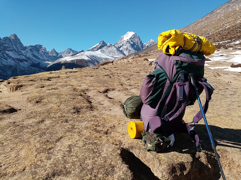
Early morning flight to Tenzing-Hillary Airport, Lukla. The 35-minute flight from Kathmandu is one of the most dramatic in the world — a narrow mountain runway perched at 2,860 m with a sharp drop at one end. From Lukla, the trail descends gently through pine forests and small Sherpa villages to Phakding on the banks of the Dudh Koshi River. An easy introduction to the terrain. Arrive at the teahouse by early afternoon.
Day 2: Phakding to Namche Bazaar (3,440 m)
The most demanding day of the first half. The trail follows the Dudh Koshi River northward, crossing several suspension bridges including the famed Hillary Bridge high above a gorge. After entering Sagarmatha National Park at Monjo and paying the park fee, the trail climbs steeply for two to three hours to reach Namche Bazaar. Just before the final ridge, on a clear day, Everest appears framed between the valley walls — a first glimpse that stops most trekkers in their tracks.
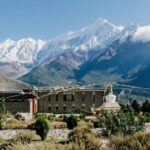
Namche sits at 3,440 m in a natural amphitheatre and is the commercial and cultural capital of the Khumbu Sherpa people. It has everything: bakeries, gear shops, Wi-Fi, good food, and a remarkable Saturday market that has been running for centuries. It’s also where the trail diverges — south toward the Lukla return and north into the Gokyo Valley.
Day 3: Acclimatisation in Namche Bazaar
A full rest day is non-negotiable. Above 3,000 m, the body needs time to adjust its red blood cell production and respiratory patterns. The worst decision a trekker can make is pushing higher too quickly. Acclimatisation days aren’t wasted time — they’re the difference between completing the trek and being evacuated by helicopter.
The recommended day hike goes up to Hotel Everest View at 3,880 m — the Guinness-record holder for world’s highest hotel — where you can see Everest, Lhotse, Nuptse, and Ama Dablam from the terrace. Return to Namche for the night. Many trekkers also visit the Sagarmatha National Park Visitor Centre nearby, which has good displays on Khumbu geology, ecology, and Sherpa history.
Day 4: Namche Bazaar to Dole (4,040 m)
This is the day the trek changes character. From Namche, the trail climbs to a high ridge offering panoramic views of Ama Dablam, Thamserku, and Kantega, then follows the contour north along the western flank of the Khumbu valley — a completely different trail from the EBC route. The crowd thins noticeably. The path passes through Khumjung and Phortse before descending into the upper reaches of the Dudh Koshi and climbing to Dole, a small settlement at 4,040 m surrounded by open alpine grazing land. The altitude starts to be felt here.
Day 5: Dole to Machhermo (4,470 m)
A shorter day with steady altitude gain. The trail climbs through sparse rhododendron and juniper scrub, past yak herding huts and mani stone walls, to the small cluster of lodges at Machhermo at 4,470 m. Views of Cho Oyu (8,188 m — the world’s sixth highest peak) begin to open up to the north. A 1993 snow leopard attack on a yak herd near Machhermo was widely reported; the Khumbu still has a viable snow leopard population, though sightings are rare and considered exceptional luck. Rest in the afternoon. Drink water.
Day 6: Machhermo to Gokyo (4,790 m)
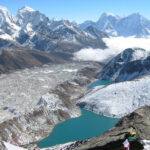
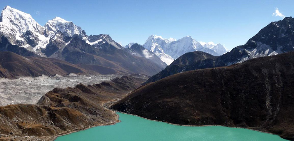
The trail continues up the valley floor, flanked by the vast lateral moraine of the Ngozumpa Glacier — Nepal’s longest glacier at roughly 36 km. The scale of the moraine is staggering: a river of rubble and ice hundreds of metres wide. As the valley opens, the first and second Gokyo Lakes appear in succession, their turquoise colour almost unnaturally vivid against the grey rock and white glacier.
Gokyo village sits at 4,790 m on the western shore of the third lake, Dudh Pokhari. The lodges here are comfortable by mountain standards and the setting is extraordinary — glacial lake behind you, glacier to the east, and Gokyo Ri looming directly above. The evening light on the water turns the lake gold and then dark blue in the span of twenty minutes. Have dinner early and sleep as much as possible.
Day 7: Acclimatisation — Gokyo Ri Summit (5,357 m) and Lake Exploration
The highlight of the entire trek. Rise before first light and begin the ascent of Gokyo Ri, the prominent hill directly above the village. The climb takes two to three hours depending on pace and is steep throughout — but the summit, reached at dawn, is one of the great mountain experiences in Asia.
From the top of Gokyo Ri at 5,357 m, four 8,000-metre peaks are visible simultaneously: Everest (8,849 m) to the east, Lhotse (8,516 m) just right of it, Makalu (8,485 m) further right, and Cho Oyu (8,188 m) dominating the northwest. The Ngozumpa Glacier stretches below in both directions. The Gokyo Lakes glitter in the valley. Most trekkers who’ve also stood on Kala Patthar (the EBC viewpoint) say this is better. The absence of crowds reinforces the feeling.
Descend to Gokyo for breakfast, then spend the afternoon exploring the second and third lakes or simply resting at altitude. The acclimatisation effect of spending a second night at Gokyo is significant and helps prepare the body for the return descent.
Day 8: Optional — 4th and 5th Lakes Excursion
For trekkers with energy and time, a walk north along the glacier moraine reaches the fourth lake (Thonak Cho, 4,950 m) and fifth lake (Ngozumpa Tso, approximately 5,000 m). The fifth lake is the highest of the main Gokyo lakes and offers a close view of the glacier’s upper reaches and the peaks to the north and west. The landscape up here is raw, almost lunar — fractured ice, loose moraine, and absolute silence. Return to Gokyo for the night. Some trekkers use this as a rest day instead, particularly if planning the Renjo La Pass extension.
Day 9: Gokyo to Dole (4,040 m)
Descent begins. The trail retraces the approach through the valley, past the lakes, alongside the glacier moraine, and back down to Dole. What took two days of climbing takes one long afternoon down. Legs feel stronger than expected going downhill; knees feel the sustained gradient by late afternoon. A descent of over 700 m in elevation, but the pace is easy and the views back up toward Gokyo and Cho Oyu are excellent.
Day 10: Dole to Namche Bazaar (3,440 m)
Back through Khumjung and down the high contour trail to Namche. The descent into the town feels like re-entering civilisation: real coffee, proper hot showers, faster Wi-Fi, and a range of restaurants. Celebrate the completion of the high section with a good meal. Many trekkers report sleeping noticeably better at Namche after nights above 4,700 m.
Day 11: Namche Bazaar to Lukla (2,860 m)
The long walkout. The return trail covers the same ground as days one and two in reverse — down from Namche, across the Hillary Bridge, along the Dudh Koshi, and back up to Lukla. Seven hours of walking, mostly downhill, with the last hour being a climb to the airport town. Arrive in Lukla by late afternoon. Dinner, rest, and prepare for the early morning flight.
Day 12: Lukla to Kathmandu (Flight)
Morning flights only — weather windows in the Khumbu typically close by mid-morning. The return flight follows the same dramatic approach in reverse. Back in Kathmandu by late morning. If you have a connecting international flight, build a full buffer day (Day 13) into the itinerary. Weather-related delays at Lukla are common, particularly in spring.
Renjo La Pass Extension (Days 13–14)
For trekkers with two extra days, the Renjo La Pass circuit is one of the best extensions available anywhere in the Khumbu. Instead of descending back the same way from Gokyo, you head west over Renjo La Pass at 5,360 m, descend into the Thame Valley, and return to Namche from the west.
The pass crossing is a demanding day — 7 to 8 hours with a steep ascent and a rocky descent that can hold ice in early spring and late autumn. Start before dawn. The views from Renjo La are genuinely among the finest in the entire Everest region: Everest and the main Khumbu peaks are directly ahead as you ascend, the Gokyo Lakes visible behind you, and the Rolwaling range spread across the horizon to the west. Many trekkers who’ve crossed both Renjo La and Kala Patthar say the Everest view from Renjo La is superior.
The descent reaches Lungdeng (4,368 m) and then Thame village (3,820 m), one of the oldest Sherpa settlements in the Khumbu and the home village of Tenzing Norgay. From Thame, a half-day walk returns to Namche, from where the standard return to Lukla and Kathmandu continues.
Top Highlights of the Trek
- Gokyo Ri (5,357 m) — arguably the best panoramic Everest viewpoint in Nepal, with four 8,000-metre peaks visible simultaneously from the summit
- The Gokyo Lakes — a chain of six glacial lakes at over 4,700 m, sacred to both Hindus and Buddhists, with extraordinary turquoise colouration
- Ngozumpa Glacier — Nepal’s longest glacier at approximately 36 km, visible throughout the upper valley section of the trek
- Namche Bazaar — the Khumbu’s commercial and cultural capital, a remarkable mountain town at 3,440 m
- Sagarmatha National Park — UNESCO World Heritage Site protecting rare Himalayan wildlife including snow leopard, Himalayan tahr, and musk deer
- Sherpa villages — Dole, Machhermo, Khumjung, and Gokyo itself, with teahouses run by local Sherpa families
- Renjo La Pass (5,360 m, extension only) — a dramatic high pass with sweeping views of Everest, the Gokyo Lakes, and the Rolwaling range
- Thame Valley (extension only) — a quiet, rarely visited valley home to ancient monasteries and Mani Rimdu festival traditions
- Cho Oyu views — the world’s sixth highest peak dominates the northern horizon throughout the upper valley
Difficulty and Fitness
The Gokyo Lake Trek is rated moderate to challenging. It’s a step up from the Everest View Trek but sits below the Everest Three Passes Trek in terms of technical difficulty. The standard 12-day route requires no technical climbing, but several factors make it genuinely demanding.
The maximum altitude on the standard route is 5,357 m (Gokyo Ri). You’ll spend two nights at 4,790 m in Gokyo and multiple nights above 4,000 m. At these altitudes, oxygen availability is roughly 50–60% of sea level. Simple tasks become effortful. Sleep is disrupted. Appetite drops. These are normal responses to high altitude — the key is to ascend slowly and let the body adapt.
Daily walking time ranges from 4 to 8 hours. The terrain is varied: well-maintained stone trails near Namche, rough valley paths in the upper Gokyo Valley, loose moraine near the glacier, and steep scree slopes on the Gokyo Ri ascent. Trekking poles are strongly recommended.
Recommended preparation: 10–14 weeks of training before departure. Prioritise cardiovascular endurance (running, cycling, swimming) and lower body strength (hiking with a loaded pack, stair training, squats). If this is your first high-altitude trek, do a shorter warm-up trek or spend a day hiking in the hills above Kathmandu on arrival.
Permits and Documentation
Two permits are required. Arrange them in Kathmandu before departing for Lukla. Any reputable operator will handle this for you, but confirm that permit costs are included in your package price.
- Sagarmatha National Park Entry Permit — approx. NPR 3,000 (~USD $22) for foreign nationals. Checked at the park gate south of Namche.
- Khumbu Pasang Lhamu Rural Municipality Permit — approx. NPR 2,000 (~USD $15). Checked at multiple points along the trail.
Both permits require a valid passport and two passport-sized photos. Some itineraries that cross Renjo La Pass may require an additional TIMS (Trekkers’ Information Management System) card — confirm with your operator before departure as regulations can change seasonally.
Best Time to Go
- March to May (spring): Rhododendron forests in full bloom between Namche and the upper valley. Good visibility, mild daytime temperatures. The busiest month is April/May when Everest climbing season draws significant traffic to Namche, though the Gokyo trail itself stays quieter.
- October to November (autumn): Peak season for clarity. Post-monsoon skies are sharp and stable. The mountains are freshly snowed and the air is clean. Book teahouses and Lukla flights well in advance — October in the Khumbu is one of Nepal’s busiest trekking periods.
- December to February (winter): Extremely cold above 4,000 m. Renjo La Pass and upper valley approaches may be snow-blocked. Suitable only for experienced winter trekkers with full cold-weather kit and a robust acclimatisation plan.
- June to September (monsoon): Heavy rainfall, poor visibility, leech-infested lower trails, and frequent Lukla flight cancellations. Not recommended for this route.
Accommodation
The route is well served by teahouses from Phakding to Gokyo. Quality drops as altitude increases, which is expected and entirely manageable.
- Namche Bazaar: Best selection on the route. Private rooms with attached bathrooms, hot showers, reliable Wi-Fi, and a wide menu. Some lodges here approach mid-range hotel standards.
- Dole and Machhermo: Functional teahouses with basic rooms. Shared bathrooms, limited hot water (often solar-heated). Warm enough if you have a sleeping bag liner.
- Gokyo: Several lodges of reasonable quality for the altitude. The best ones face the lake. Communal dining rooms with yak-dung stoves — the main source of warmth above 4,500 m. Private rooms available but expect thin walls and cold floors.
Meals across the route include the standard Himalayan teahouse menu: dal bhat (lentil rice — unlimited refills, and the best calorie-to-cost ratio on the trail), pasta, noodles, soups, eggs, and fried rice. Prices increase noticeably above Namche. Gokyo is approximately twice as expensive as Namche for the same dish. Bring sufficient cash in Nepali Rupees — the nearest ATMs are in Namche.
How Much Does It Cost?
| Category | Approximate Cost (USD) |
| Budget trek (independent + local guide hire) | $700–$1,000 |
| Mid-range package (operator inclusive, 12 days) | $1,000–$1,500 |
| Fully inclusive with Renjo La extension (14–16 days) | $1,500–$2,200 |
| Lukla return flights (from Kathmandu) | $220–$350 return |
| Permits (both) | $37 (NPR 5,000 combined) |
| Tipping (guide + porter, per day) | $12–$17 per day total |
Guide hire is strongly recommended for this route. You’ll be spending multiple nights above 4,500 m, crossing remote terrain, and managing altitude-related health risks. The cost of a licensed guide is minimal relative to the safety and logistical value they provide.
What to Pack
Clothing
- Moisture-wicking base layers, top and bottom (merino wool or synthetic)
- Fleece mid-layer — worn most evenings at Gokyo and above
- Down jacket rated to at least -10°C — essential above 4,500 m
- Waterproof hard-shell jacket and trousers
- Trekking trousers — convertible zip-off style ideal
- Warm hat, sun hat, lightweight balaclava, neck gaiter, gloves and liner gloves
- Trekking boots — broken in before departure, waterproof, with ankle support
- Camp shoes or lightweight sandals for teahouse evenings
Gear
- Trekking poles — critical for descent days and the Gokyo Ri ascent
- Daypack (25–35 litres) — your porter carries the main duffel
- Sleeping bag rated to -10°C or lower, plus a liner
- Headlamp with spare batteries and a backup lamp
- Glacier glasses or UV400 mountain sunglasses — essential above 4,500 m
- High-SPF sunscreen (factor 50+) and protective lip balm
- Water purification tablets or a UV Steripen — critical above Namche
- 2-litre water capacity (bottles or hydration bladder)
- Personal first aid kit: blister pads, Ibuprofen, antihistamine, Diamox (consult a GP), re-hydration salts
- Portable power bank (10,000 mAh minimum) — charging points are scarce above Namche
- Lightweight down sleeping mat cover (optional but valuable in basic teahouses)
Health, Safety, and Altitude
The Gokyo Lake Trek reaches significantly higher altitudes than the Everest View Trek. You’ll spend multiple nights above 4,500 m and summit Gokyo Ri at 5,357 m. Acute Mountain Sickness (AMS) is a genuine concern and should be taken seriously.
AMS symptoms include persistent headache, nausea, dizziness, loss of appetite, fatigue, and poor sleep. Mild symptoms are common and usually manageable with rest and hydration at the same altitude. If symptoms worsen — particularly if you develop loss of coordination, confusion, or fluid in the lungs or brain — you must descend immediately. This is not optional. No view is worth your life.
- The golden rule: never ascend if symptoms are worsening. Descend immediately if they do.
- Drink 3–4 litres of water per day. Dehydration makes AMS significantly worse.
- Avoid alcohol for the first several days at altitude. Avoid sleeping pills.
- Diamox (Acetazolamide) 125–250 mg twice daily can help prevent AMS. Get a prescription before leaving home.
- Travel insurance covering high-altitude trekking (up to 6,000 m) and emergency helicopter evacuation is mandatory. Helicopter rescue in the Khumbu costs USD $3,000–$6,000 without coverage.
- Emergency contact: Himalayan Rescue Association (HRA) clinic in Namche Bazaar is open during trekking season. Tel: +977-1-4440066
Guide and Porter
For the Gokyo Lake Trek, hiring a licensed guide is strongly recommended and, under current Nepal trekking regulations, generally required for independent international trekkers. The altitude, remoteness, and technical terrain between Machhermo and Gokyo — particularly the moraine path and Gokyo Ri ascent — make a guide genuinely valuable for navigation and safety monitoring.
Porters carry a maximum of 25–30 kg and are an essential part of the Khumbu trekking economy. Fair treatment matters. Ensure your porter has adequate clothing and equipment for the altitude, and tip at the end of the trek. A good rule of thumb: USD $7–10 per day per guide, USD $5–7 per day per porter, paid in cash at the end.
Frequently Asked Questions
How does the Gokyo Lake Trek compare to Everest Base Camp?
They share the same trailhead and the first two days. After Namche, they diverge completely. EBC goes east through the classic Khumbu valley (Tengboche, Dingboche, Lobuche) and reaches base camp at 5,364 m. Gokyo goes north through the less-travelled Gokyo Valley and tops out at Gokyo Ri at 5,357 m. The key difference: Gokyo Ri offers a better panoramic Everest view (you see it from the front, with the full massif), the trail is significantly quieter, and the lakes are a unique attraction that EBC doesn’t have. Most experienced Khumbu trekkers recommend Gokyo over EBC if you can only do one.
Can I combine Gokyo with Everest Base Camp?
Yes. The most popular combined route links Gokyo and EBC via the Cho La Pass (5,420 m), a technical snow and rock crossing that requires crampons in cold months. The combined route takes 16–19 days and is rated challenging. It’s one of the best long treks in Nepal for those with the time and fitness.
Is the Gokyo Lake Trek suitable for beginners?
It depends on the individual. First-time trekkers who are physically fit, have trained properly, and are willing to pace themselves carefully can complete this trek. However, the altitudes involved (multiple nights above 4,700 m) mean that zero prior high-altitude experience carries some risk. If this is your first time above 4,000 m, consider building in extra acclimatisation days and hiring an experienced guide who can monitor your health throughout.
What wildlife might I see on the trek?
Himalayan tahr (wild mountain goat), musk deer, Himalayan monal pheasant (Nepal’s national bird), snow pigeons, Tibetan snowcock, and various raptors. Snow leopards are present in the Khumbu but extremely rarely seen. The Ngozumpa Glacier moraine area and upper valley have the best wildlife diversity. Red pandas have occasionally been reported in the lower rhododendron forests near Phortse.
Are the Gokyo Lakes sacred?
Yes. The lakes are considered sacred sites in both Hinduism and Tibetan Buddhism. Dudh Pokhari (the third lake, adjacent to Gokyo village) is particularly significant and draws Hindu pilgrims during the Janai Purnima festival in August. Treat the lake shores with respect — no swimming, no washing in the lake, and no littering.
What is the Renjo La Pass, and should I do it?
Renjo La (5,360 m) is a high mountain pass west of Gokyo that connects the Gokyo Valley to the Thame Valley. Crossing it adds 2 days to the standard itinerary and is the most challenging section of any Gokyo route. It is highly recommended for trekkers who are fit, well-acclimatised, and have a competent guide. The views from the top are exceptional. If time is limited, skip it. If you have the days, do it.
Final Word
The Gokyo Lake Trek doesn’t get the fame it deserves. Most trekking content about the Khumbu defaults to Everest Base Camp, and most people who go to Nepal follow the crowd east from Namche. The trekkers who turn north into the Gokyo Valley tend to be quieter about it. Part of the appeal is that it stays relatively uncrowded.
The lakes are genuinely stunning in a way that photographs don’t quite capture — the colour is too vivid, the setting too dramatic to translate well. Gokyo Ri at sunrise, with Everest lit in the first light and four of the highest mountains on Earth visible at once, is one of the finest sights available to non-technical trekkers anywhere in the Himalayas.
Plan it properly. Train for it. Acclimatise correctly. Bring the right kit. And turn north at Namche.
Recent Posts