Trekking in Langtang Region
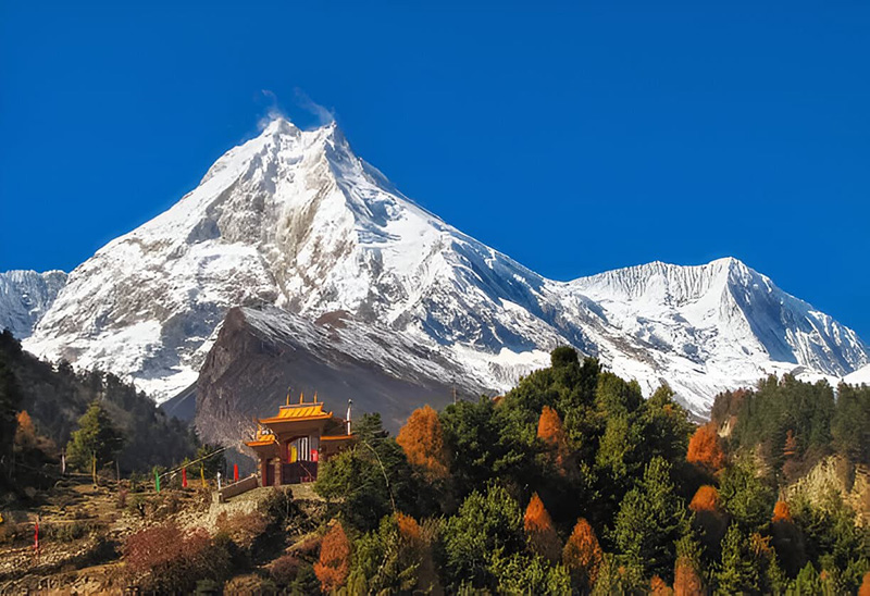
The Langtang region sits just 75 miles north of Kathmandu, yet it delivers the kind of raw, immersive mountain experience that trekkers cross the world to find. No domestic flight required, no weeks of logistical planning — a single day’s drive along the Trishuli River valley brings you to the trailhead at Syabrubesi, where the Langtang Khola roars through a gorge cut by glaciers over millennia. From there, the trail climbs through rhododendron and oak forests, past Tamang villages that have occupied these hillsides for centuries, and into the high valley that the region is named for: a long, glacial corridor walled on three sides by peaks above 6,000 meters, anchored at its head by Langtang Lirung rising to 7,227 meters.
Langtang National Park — established in 1976 as Nepal’s first Himalayan national park — protects 1,710 square kilometers of exceptional biodiversity. Approximately 25 percent of the park is forested, with belts of oak, maple, pine, and multiple rhododendron species descending from the alpine zone into the subtropical foothills. The park is home to red pandas, snow leopards, Himalayan tahr, musk deer, Himalayan black bears, and over 250 recorded bird species. For most trekkers, spotting a red panda in the bamboo forests between Syabrubesi and Lama Hotel is one of the defining moments of the region.
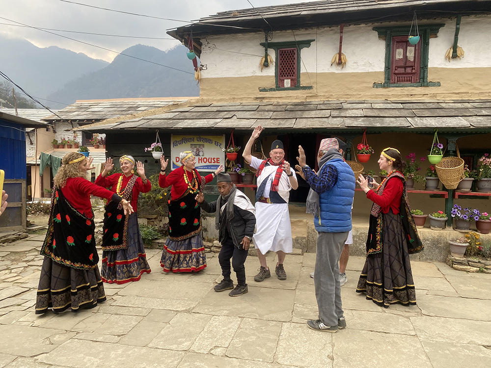
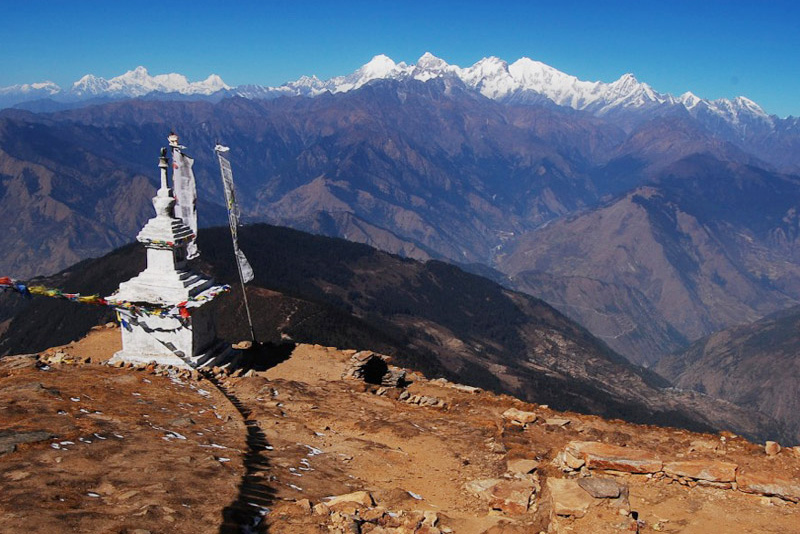
The human landscape here is equally compelling. The Langtang region is predominantly inhabited by Tamang people — an ethnic group with deep Tibetan Buddhist roots and a distinct culture expressed in their stone villages, ancient gompas, mani walls carved with prayer scripts, and the kind of quiet hospitality that emerges when a community is not yet overwhelmed by mass tourism. A smaller community of Tibetan refugees, who fled across the border following the 1959 Chinese invasion, also lives in the region, contributing Tibetan handicrafts, additional Buddhist traditions, and a second strand of cultural texture to the valley.
For trekkers based in Kathmandu with limited time, the Langtang region is the most practical choice in Nepal — and for those with more time, the combination of the Langtang Valley, Gosaikunda Lake, the Tamang Heritage Trail, and the challenging Ganja La Pass creates one of the richest multi-week trekking circuits in the country. At Getaway Nepal Adventure, we have guided hundreds of trekkers through this region and know every section of every trail personally. The Langtang does not need Everest’s reputation to earn your time. It earns it on its own terms.
Langtang Region Treks at a Glance
The Langtang region offers more route variety than most trekkers realize — from a gentle five-day cultural walk through Tamang villages to a technically demanding thirteen-day crossing of the Ganja La Pass requiring mountaineering equipment. The table below gives you the critical comparison data before you explore the individual packages.
| Trek | Days | Max Altitude | Difficulty | Price From |
| Langtang Helambu Trek | 8 | 3,500m / 11,483ft | Easy-Moderate | USD 445 |
| Langtang Valley Trek | 9 | 3,870m / 12,697ft | Moderate | USD 540 |
| Tamang Heritage Trek | 10 | 2,865m / 9,400ft | Easy-Moderate | USD 675 |
| Gosaikunda Lake Trek | 10 | 4,380m / 14,370ft | Moderate | USD 780 |
| Ganja La Pass Trek | 13 | 5,122m / 16,804ft | Strenuous | USD 1,200 |
| Ghangri Circuit Trek | 11 | 5,000m+ / 16,404ft | Hard | Enquire |
| Tilman Pass Trek | 19 | 5,322m / 17,461ft | Expert | USD 2,170 |
All packages are fully customizable. Departure date, group size, and pacing can be adjusted to fit your schedule. The Langtang Valley Trek and Gosaikunda Lake Trek can also be combined into a comprehensive fourteen-day circuit covering both the glacier valley and the sacred alpine lake — contact our team for details.
The Major Trekking Routes of the Langtang Region
The Langtang region is built around three interconnected trekking circuits that can be done independently or combined into extended multi-week journeys. Understanding what each route delivers — and how they differ — is the starting point for planning the right trip.
The Langtang Valley Trek: The Classic Route
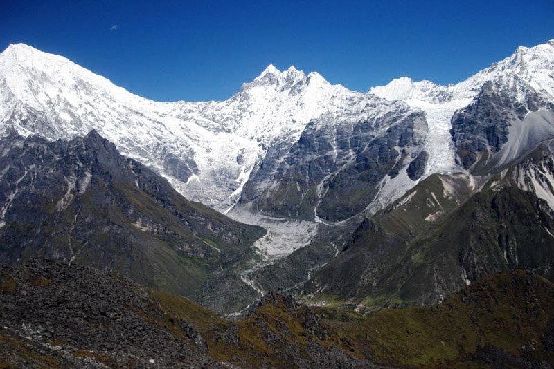
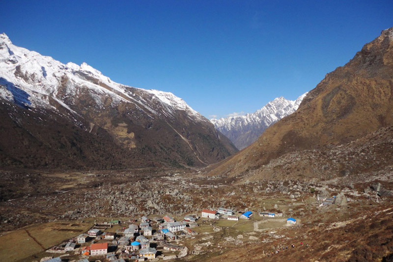
The Langtang Valley Trek is the signature route of the region. Starting from Syabrubesi at 1,462 meters, the trail climbs steadily through dense forest — look for langur monkeys and the occasional red panda in the bamboo sections below Lama Hotel — before breaking into the upper Langtang valley where the scale of the landscape changes completely. The valley floor opens, the peaks rise on all sides, and the trail runs along the glacial moraine toward Kyanjin Gompa.
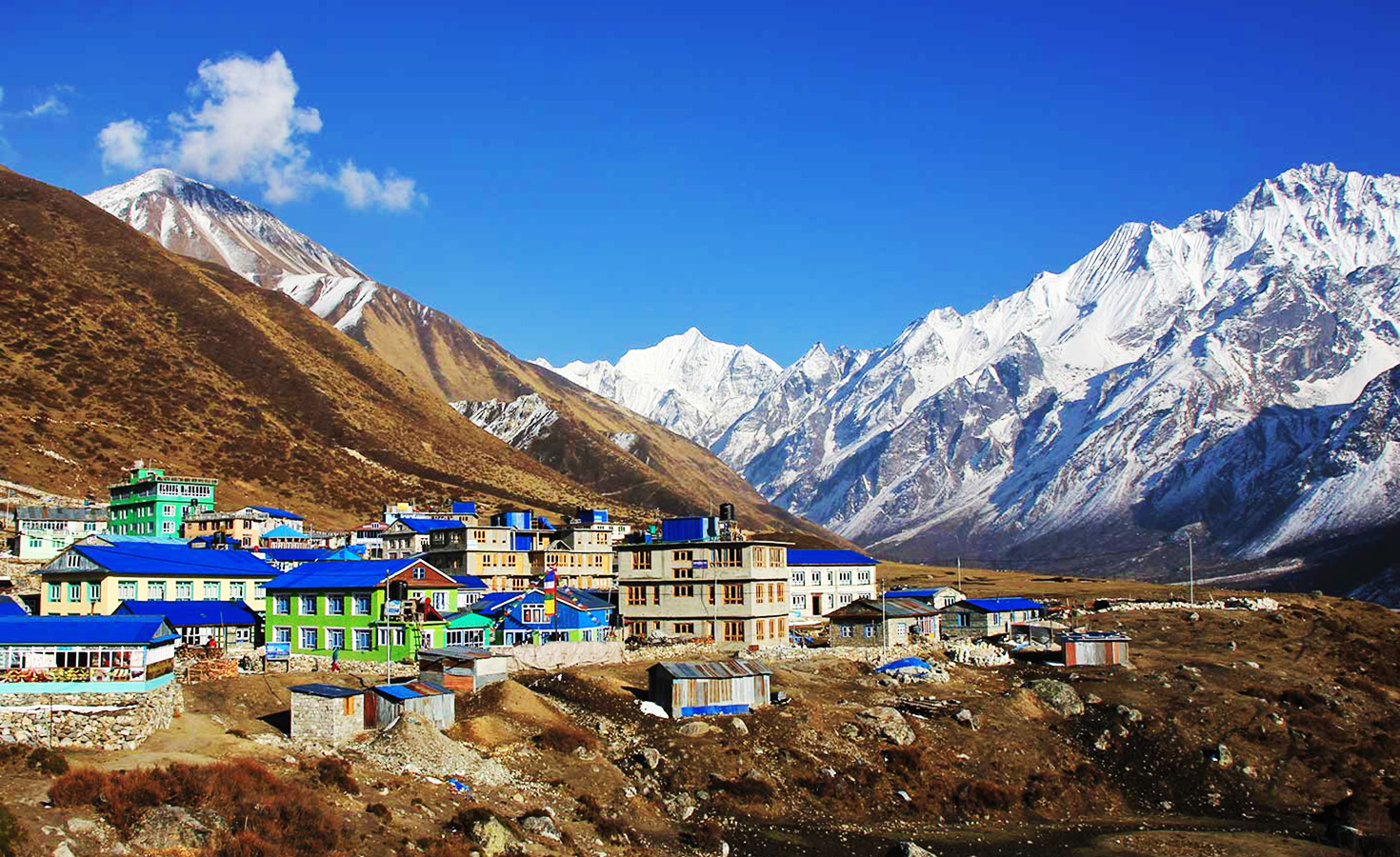
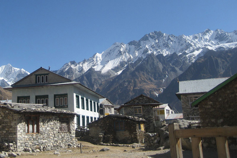
Kyanjin Gompa, at 3,870 meters, is the emotional heart of the Langtang Valley Trek. The ancient monastery here, with its whitewashed walls and spinning prayer wheels, stands at the foot of a glacier that descends from Langtang Lirung — one of the most dramatic close-range glacier views in Nepal. Adjacent to the monastery is a yak cheese factory, originally established with Swiss government aid in the 1950s, where you can watch local Tamang herders produce hard cheese from yak milk using techniques unchanged for generations. Buying a wheel of Kyanjin cheese and eating it the same evening at a teahouse is a very specific Langtang pleasure.
From Kyanjin Gompa, the most rewarding single-day extension is the ascent of Tserko Ri, a viewpoint at 4,984 meters that looks directly across the valley at Langtang Lirung, Dorje Lakpa, and — on clear days — Shishapangma in Tibet. The ascent takes four to five hours round trip from Kyanjin and is achievable for any reasonably fit trekker who has acclimatized properly over the preceding days. It is one of the finest viewpoints in the entire Langtang region.
The Gosaikunda Lake Trek: Sacred Waters at 4,380 Meters
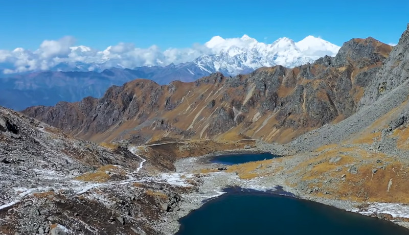
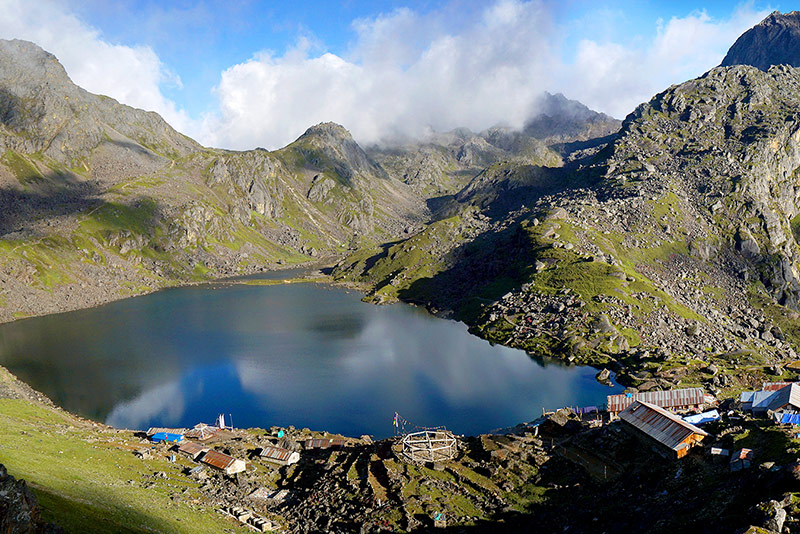
Gosaikunda Lake is one of Nepal’s most significant sacred sites — a glacial-fed freshwater lake at 4,380 meters that is revered by both Hindus and Tibetan Buddhists. According to Hindu mythology, Lord Shiva himself created the lake by striking his trident into the mountain to find cool water after swallowing the cosmic poison that threatened to destroy the universe during the primordial churning of the ocean. The lake is considered eternally connected to Shiva, and every year during the Janai Purnima festival — the full moon of August — thousands of Hindu pilgrims make the high-altitude journey to bathe in its waters, believing the ritual washes away accumulated sins and bestows spiritual merit.
For trekkers, Gosaikunda is extraordinary for different reasons. The approach from Dhunche climbs through forest and ridgeline meadows to emerge suddenly at the lake’s edge — a moment of spatial shift, from enclosed trail to open high-altitude sky, that surprises even experienced trekkers. The lake is surrounded by smaller sacred lakes: Bhairav Kunda, Saraswati Kunda, and Surya Kunda. On clear days, the reflections of the surrounding peaks in the lake’s still morning surface are among the best photographic moments in the entire Langtang region.
The Gosaikunda trek also connects to the Langtang Valley via the Lauribina La Pass at 4,610 meters, making a combined Langtang Valley and Gosaikunda circuit practical within twelve to fourteen days. This combined route allows trekkers to experience both the glacier valley and the high sacred lake without retracing any trail — the most efficient and satisfying way to cover the region’s two flagship destinations.
The Tamang Heritage Trek: Culture First, Mountains Second
The Tamang Heritage Trek was developed specifically to give visitors access to the traditional Tamang villages and Buddhist culture of the Langtang region’s middle hills — villages that the main Langtang Valley trail bypasses entirely. The route loops through settlements including Gatlang, Tatopani, Nagthali, Briddim, and Thuman, where Tamang families still live in traditional stone farmhouses, practice subsistence farming on steep terraced fields, and maintain the Buddhist monasteries that have been the spiritual centers of their communities for centuries.
The maximum altitude of the Tamang Heritage Trek is approximately 2,865 meters at Nagthali, making it genuinely accessible to trekkers who are not ready for the altitude demands of the Langtang Valley or Gosaikunda routes. The walking is moderate — four to five hours per day on average — through landscapes that alternate between rhododendron forest, cultivated hillside, and open ridge with mountain views. This is the right choice for cultural travelers, family groups with younger or older members, or anyone doing their first multi-day Himalayan trek and wanting to ease into the experience.
The Ganja La Pass Trek: The Expert Route
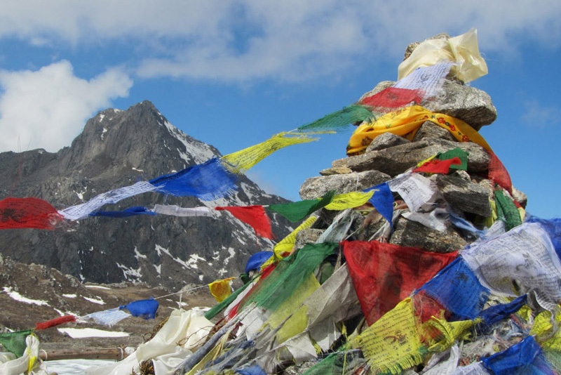
The Ganja La Pass, at 5,122 meters, connects the Langtang Valley with the Helambu region to the south and east. It is one of the most technically demanding passes in the Langtang region — not a walk up a high pass but a genuine high-altitude mountaineering crossing that requires crampons, ice axes, and experience with fixed ropes on snow slopes that average 50 degrees in steepness. The pass is covered in snow and ice year-round. Beyond Kyanjin Gompa, there are no teahouses until Tarke Gyang in Helambu — the Ganja La section is a camping trek.
For trekkers with the right background, the Ganja La delivers a Langtang experience that the standard valley route cannot match. The summit views encompass Langtang Lirung, Dorje Lakpa at 6,990 meters, Gangchenpo, Langshisa Ri, and — looking south — the forested ridges of Helambu spread across the foreground. The descent into Helambu passes through Keldang and the ancient Hyolmo Buddhist village of Tarke Gyang, adding an entirely different cultural layer to the journey.
Our thirteen-day Ganja La Pass Trek is structured with a mandatory acclimatization period at Kyanjin Gompa, which includes an ascent of Tserko Ri for high-altitude preparation. Only trekkers with prior experience at altitude above 4,500 meters and good physical conditioning should attempt the Ganja La. If you are considering this route, discuss your trekking history with our team before booking — we will give you an honest assessment.
Langtang Region Trekking Permits 2026
Trekking in the Langtang region requires two permits. Both are straightforward to obtain before you leave Kathmandu, and Getaway Nepal Adventure handles all documentation as part of every standard package. Do not wait until you reach Dhunche or Syabrubesi to buy permits — officials at checkpoints will turn you back if you arrive without them, and the process takes longer at trail checkpoints than in Kathmandu offices.
| Permit | Cost (Foreign Nationals) | Cost (SAARC Nationals) | Where to Obtain |
| Langtang National Park Entry Permit | NPR 3,000 (USD 25) plus 13% VAT = ~NPR 3,390 total | Reduced rate applies | Nepal Tourism Board (NTB) office, Bhrikutimandap, Kathmandu. Also available at the Dhunche park entrance — but buy in Kathmandu to avoid delays. |
| TIMS Card (Trekkers’ Information Management System) | NPR 1,000 for agency-organized group trekkers / NPR 2,000 for independent trekkers | Reduced rates apply | NTB or TAAN office in Kathmandu. Unlike the Everest region, TIMS remains mandatory for Langtang in 2026. Bring passport, 2 passport photos, and visa copy. |
Important: TIMS Is Still Required in Langtang in 2026
Unlike the Everest region, where TIMS was discontinued and replaced by a local municipality permit,
TIMS remains an active requirement for the Langtang region in 2026.
Checkpoint officials at Dhunche, Ghodatabela, and along the Gosaikunda approach verify both the National Park permit and the TIMS card. Do not rely on outdated information that lists only one permit for Langtang — you need both.
Total combined permit cost for most foreign trekkers: approximately NPR 4,390 to 5,390 (USD 33-42).
Permit checkpoints are located at Dhunche (the main park entrance for Langtang and Gosaikunda routes), Ghodatabela (approximately three to four hours beyond Lama Hotel on the valley trail), and occasionally at points closer to Langtang village. Keep original permits accessible in a waterproof document pouch throughout the trek — inspectors will ask for originals, not phone photographs.
For the Ganja La Pass Trek, which crosses into the Helambu region, the same two permits cover the entire route. No additional Helambu permit is required when approaching from Langtang. The Tilman Pass Trek, which ventures into remote terrain bordering Tibet, may require additional documentation — our team will advise on the current requirements at the time of booking.
Getting to the Langtang Region from Kathmandu
The Langtang region is the most accessible of Nepal’s three major trekking destinations in terms of proximity to Kathmandu. No domestic flight is required, and the road journey itself passes through genuinely beautiful river valley country that most trekkers find a pleasure rather than a chore.
Option 1: Tourist Bus or Private Vehicle to Syabrubesi
The standard route takes you northwest from Kathmandu along the Trishuli River valley to Dhunche (the district headquarters of Rasuwa and the main park permit checkpoint), then onward to Syabrubesi — the starting point for the Langtang Valley Trek. Total driving time from Kathmandu is seven to eight hours by tourist bus or five to six hours by private vehicle, depending on road conditions and seasonal traffic.
The road passes through Trishuli Bazaar and follows the river gorge north through increasingly dramatic scenery. The final section from Dhunche to Syabrubesi involves switchbacks above the river on a mountain road that is entirely safe but gives a clear preview of the terrain to come. Most trekkers depart Kathmandu at 6:00 to 7:00 AM and arrive at Syabrubesi in time for a late afternoon check-in, an acclimatization walk around town, and an early dinner before the first full day of walking.
Getaway Nepal Adventure arranges private vehicle transfers from your Kathmandu hotel to Syabrubesi as part of every standard Langtang package. Tourist bus options are available for budget travelers — departures are from the Machhendra Bahal area of Kathmandu, typically at 7:00 AM.
Option 2: Starting From Dhunche (Gosaikunda Route)
Trekkers doing the Gosaikunda Lake Trek specifically can begin at Dhunche rather than Syabrubesi. Dhunche sits at approximately 1,965 meters on the main road, making it slightly higher than Syabrubesi and a direct starting point for the Gosaikunda approach via Sing Gompa and Lauribina. The drive to Dhunche from Kathmandu is approximately the same duration as to Syabrubesi — six to seven hours — as Syabrubesi lies an additional thirty to forty minutes beyond Dhunche on the same road.
For trekkers combining Gosaikunda and Langtang Valley in a circuit, the most common approach is to start at Syabrubesi (lower), trek up the Langtang Valley to Kyanjin Gompa, return partway down the valley, and then cross to the Gosaikunda route via the ridge trail to Lauribina and Gosaikunda before descending to Dhunche. This circuit can be done in reverse but most guides prefer the valley-first direction as it allows better acclimatization before reaching Gosaikunda’s 4,380-meter altitude.
Altitude and Acclimatization in the Langtang Region
The Langtang region has a more varied altitude profile than most trekkers expect. The valley floor at Syabrubesi starts low — just 1,462 meters — and the routes rise across a wide range depending on your destination. Understanding where the altitude challenges actually occur prevents the most common mistake: underestimating the gain to Gosaikunda and Ganja La.
| Location | Altitude | Trek / Significance |
| Syabrubesi (trailhead) | 1,462m / 4,797ft | Starting point for Langtang Valley and Gosaikunda treks |
| Lama Hotel | 2,380m / 7,808ft | First main teahouse stop — forest zone, red panda habitat |
| Langtang Village | 3,430m / 11,253ft | Rebuilt Tamang village — first altitude acclimatization point |
| Kyanjin Gompa | 3,870m / 12,697ft | End of main Langtang Valley Trek — monastery, cheese factory |
| Tserko Ri (viewpoint) | 4,984m / 16,352ft | Best panoramic viewpoint in the valley — optional day hike |
| Lauribina La Pass | 4,610m / 15,125ft | High pass connecting Langtang Valley to Gosaikunda |
| Gosaikunda Lake | 4,380m / 14,370ft | Sacred Hindu-Buddhist alpine lake — Gosaikunda Trek destination |
| Ganja La Pass | 5,122m / 16,804ft | Highest point in Langtang region — technical, camping required |
| Tilman Pass | 5,322m / 17,461ft | Highest standard Langtang route — expert level only |
Acclimatization on the Langtang Valley Trek
The standard nine-day Langtang Valley Trek gains altitude gradually enough that well-structured itineraries carry a low AMS risk for most trekkers. The critical nights are at Langtang Village (3,430 meters) — the body’s first sustained exposure to high altitude on this route — and Kyanjin Gompa (3,870 meters). Our itinerary builds a rest day at Kyanjin Gompa, during which most trekkers make the day hike to Tserko Ri. This climb-high-sleep-low pattern is not optional in our scheduling — it is the reason our trekkers reach Kyanjin without significant altitude problems.
Watch for AMS symptoms at and above 3,000 meters: persistent headache, nausea, dizziness, loss of appetite, and disrupted sleep. Mild symptoms are common and manageable with rest and hydration. If symptoms worsen rather than improve after 24 hours of rest at the same altitude, descend. Our guides carry pulse oximeters and are trained in wilderness first aid. The descent decision is always the guide’s call — and it is always final.
Acclimatization on the Gosaikunda Trek
The Gosaikunda Lake Trek presents a more concentrated altitude challenge than the valley route. The trail ascends from Dhunche at 1,965 meters to Gosaikunda at 4,380 meters over approximately three days — a gain of more than 2,400 meters in a compressed timeframe. Our ten-day itinerary paces this gain deliberately, with a night at Sing Gompa (3,250 meters) as an intermediate acclimatization stop before continuing to Lauribina and Gosaikunda.
Trekkers doing the combined Langtang Valley plus Gosaikunda circuit benefit from the acclimatization built during the valley section — arriving at Gosaikunda from the Langtang side, after several nights above 3,000 meters, reduces the AMS risk substantially compared to approaching directly from Dhunche. If your schedule allows the combined circuit rather than the straight Gosaikunda approach, the combined route is the physiologically safer and experientially richer option.
Best Time to Trek the Langtang Region
The Langtang region’s trekking seasons closely mirror those of the Everest and Annapurna regions, with the same fundamental pattern of two excellent windows bracketing a difficult monsoon season. However, the Langtang’s lower overall altitude on the main valley trail and its proximity to Kathmandu give it some seasonal flexibility that the other regions lack.
Spring: March Through May
Spring is one of the two prime trekking seasons in Langtang. The rhododendron forests between Syabrubesi and Lama Hotel burst into bloom from late February through April, with deep crimson and pink flowers covering the hillsides in a display that rivals anything in the Annapurna region. Temperatures on the valley trail are comfortable — typically 5 to 15 degrees Celsius at mid-altitude during the day — and the sky is generally clear in the mornings, with afternoon cloud building from late April into May.
The Gosaikunda Lake is typically still partially frozen in March and fully thawed by late April, making late April through May the optimal window for the lake trek in spring. The Ganja La Pass requires good snow conditions for safe crossing; most experienced operators run the Ganja La in late April through mid-May when the snow is consolidated but not icy and new snowfall is less frequent.
Autumn: September Through November
Autumn is the finest overall season in the Langtang region. The monsoon clears in September, leaving the forest luminously green, the rivers running full, and the air so clean that the peaks seem closer than the map says they should be. October is the peak month — consistently clear skies, excellent visibility from Tserko Ri and Gosaikunda’s approach ridges, and the orange-gold of deciduous oaks adding color to the forest zones below 3,000 meters.
November is excellent for the valley and Gosaikunda routes and remains good through mid-month. From late November, high passes including the Ganja La become progressively more hazardous with early winter snowfall. The main Langtang Valley trail and Gosaikunda route remain viable through November with appropriate cold-weather gear.
Monsoon: June Through August
The monsoon arrives in Langtang in early June and delivers heavy, daily rainfall across the lower and mid-altitude sections of the region. The forest trails become slippery and leech-infested below 2,500 meters, river levels rise, and some bridge crossings on the Langtang Khola can become impractical after major rainfall events. Mountain views above the clouds are inconsistent at best.
However, the Gosaikunda Trek during Janai Purnima (the full moon festival of August) is a genuinely unique cultural experience — the combination of thousands of Hindu pilgrims making their way to the sacred lake, the spiritual energy of the festival itself, and the dramatic monsoon landscapes creates something that no other trekking season delivers. If you are interested in experiencing Gosaikunda at its most culturally charged moment, plan for the Janai Purnima pilgrimage window. Be prepared for crowded trail sections and limited teahouse availability in the days immediately before and after the festival.
Winter: December Through February
Winter in the lower Langtang valley is cold but manageable. Between Syabrubesi and Lama Hotel, daytime temperatures stay above freezing, and the trails are generally clear of snow. Above Lama Hotel, snowfall becomes frequent from December, and the upper sections of the Langtang Valley near Kyanjin Gompa can be snowbound and very cold (nighttime temperatures below minus 15 degrees Celsius) from January through February. Teahouses above Langtang Village may close during the coldest weeks.
For confident, well-equipped winter trekkers, the lower Langtang Valley and Tamang Heritage Trail offer genuinely beautiful winter walking — quiet trails, clear skies, and the particular quality of Himalayan light on snow-capped peaks in the dry winter air. The Gosaikunda approach is not recommended in winter due to snow on the ridge sections between Sing Gompa and Lauribina.
How Difficult Are the Langtang Treks?
The Langtang region covers the full spectrum from gentle cultural walks to technical high-pass crossings requiring mountaineering skills. The critical variables are altitude and terrain type — not raw fitness alone.
| Trek | Fitness Required | Altitude Risk | Best Suited For |
| Tamang Heritage Trek | Low-Moderate | Low (max 2,865m) | First-time trekkers, cultural travelers, families, those wanting villages without high altitude |
| Langtang Helambu Trek | Low-Moderate | Low-Moderate | Trekkers wanting a combined cultural and mountain experience in eight days |
| Langtang Valley Trek | Moderate | Moderate (3,870m) | Most adults with reasonable fitness — Nepal’s third most popular trekking route |
| Gosaikunda Lake Trek | Moderate | Moderate (4,380m) | Trekkers interested in spiritual landscapes and high alpine scenery |
| Ganja La Pass Trek | High | High (5,122m) | Experienced trekkers with prior high-altitude history and technical climbing comfort |
| Tilman Pass Trek | Expert | High (5,322m) | Expedition-level trekkers only — remote, multi-week, camping-based route |
The Langtang Valley Trek is often described as Nepal’s best moderate Himalayan trek — a description we agree with. The trail gains altitude gradually from a low starting point, the distance between teahouses is reasonable, and the cultural and natural rewards per day of walking are among the highest in the country. If you can walk five to six hours a day on uneven terrain, you can complete the Langtang Valley Trek.
The one consistent underestimation we see from trekkers is the Gosaikunda route. The compressed altitude gain from Dhunche to the lake — nearly 2,400 meters in three days — makes this route harder than its “moderate” grading suggests to trekkers who are not already acclimatized. Our itinerary paces this appropriately. If you are booking a standalone Gosaikunda trek rather than the combined circuit, trust the pace of the schedule rather than trying to compress it.
Why Trek the Langtang Region with Getaway Nepal Adventure
The Langtang region has fewer agencies operating in it than Everest or Annapurna, and the quality gap between operators is more noticeable here than on the heavily trafficked main routes. The remoteness that makes Langtang rewarding also means that the consequences of choosing a poorly organized trip — underequipped porters, untrained guides, inadequate emergency planning — are more significant.
Guides with Personal Connections to the Region
Several of our guides for the Langtang region grew up in Tamang villages in the Rasuwa district — in some cases, in villages that the treks pass through directly. This is not a selling point we manufacture. It is a practical reality that affects every day of your trek: a guide who grew up in Briddim or Gatlang knows who the local tea maker is, which monastery allows observers during morning puja, and where the red pandas are most reliably spotted in the bamboo belt below Lama Hotel. That knowledge cannot be replicated by a Kathmandu-based guide who has learned the route from a map and two previous trips.
For Ganja La Pass Trek clients, we use only guides with documented prior crossings of the pass and certified wilderness first aid training. The technical nature of the Ganja La crossing is not compatible with on-the-job learning.
Commitment to the Post-2015 Community
We made a deliberate decision after the 2015 earthquake to prioritize the Langtang region in our operations — not as charity, but as a sustainable business commitment to a community that needed tourism revenue to fund its own recovery. Our teahouse selections, guide hiring, and porter contracting on Langtang routes are structured to distribute economic benefit to the communities that were most severely affected. We can tell you exactly which teahouses we use and why we chose them. We can tell you our guides’ home villages. That level of transparency is not accidental — it reflects how we think our business should operate in a region with the history Langtang has.
Small Groups, Genuine Flexibility
Maximum group size for standard Langtang treks is twelve trekkers, and in practice most of our groups are significantly smaller. In a region with as few services and as much genuine remoteness as the upper Langtang Valley and Gosaikunda approach, small group size is not just a comfort preference — it is a safety and logistical practical. A group of six can make a genuine rest day decision when one member shows altitude symptoms. A group of eighteen cannot.
Frequently Asked Questions About Trekking in the Langtang Region
Q1: What permits do I need to trek in the Langtang region in 2026?
Two permits are required: the Langtang National Park Entry Permit and the TIMS Card. The National Park permit costs NPR 3,000 (approximately USD 25) for foreign nationals, plus 13% VAT, bringing the total to approximately NPR 3,390. The TIMS Card costs NPR 1,000 for group trekkers organized through a registered agency. Unlike the Everest region, TIMS remains mandatory in Langtang in 2026. Buy both permits at the Nepal Tourism Board office in Kathmandu before departure — buying at the Dhunche checkpoint is possible but slower, and buying the park permit at a checkpoint rather than in advance costs double (NPR 6,000). Getaway Nepal Adventure obtains all permits as part of every standard package.
Q2: What is the best time of year to trek in the Langtang region?
Spring (March to May) and autumn (September to November) are the two prime trekking seasons. October offers the finest conditions overall: post-monsoon clarity, excellent visibility, and stable temperatures. Spring is equally popular and offers the bonus of rhododendron blooms across the forest sections between Syabrubesi and Lama Hotel, which are spectacular in March and April. Winter (December to February) is viable for the lower-altitude Tamang Heritage Trail and lower Langtang Valley sections, though the upper valley above Langtang Village becomes cold and potentially snowbound. Avoid June through August on the main routes — the monsoon makes the lower trails slippery and leech-infested and eliminates mountain views.
Q3: How far is the Langtang region from Kathmandu?
Syabrubesi, the main trailhead for the Langtang Valley and Gosaikunda treks, is approximately 120 kilometers from Kathmandu by road. The drive takes seven to eight hours by tourist bus or five to six hours by private vehicle. Dhunche, the main park checkpoint and starting point for the Gosaikunda approach, is approximately 30 to 40 minutes shorter. No domestic flight is required — making the Langtang region the most accessible of Nepal’s three major trekking destinations from Kathmandu. Getaway Nepal Adventure arranges private vehicle transfers from your Kathmandu hotel to the trailhead as part of every standard package.
Q4: Is the Langtang Valley Trek safe after the 2015 earthquake?
Yes, completely. The 2015 earthquake and subsequent avalanche caused devastating losses in the Langtang Valley, but in the decade since, the community and government have rebuilt trails, rerouted sections that crossed hazardous terrain, and reconstructed teahouses using earthquake-resistant building techniques. Langtang Village was rebuilt on stable ground beyond the old debris field. All permit checkpoints operate normally. The full route from Syabrubesi to Kyanjin Gompa is safe, well-maintained, and actively trekked year-round. The evidence of 2015 is visible in the landscape — trekkers pass the boundary of the old avalanche deposit — but the trail is safe and the community is thriving. Your visit contributes directly to that recovery.
Q5: What is the Gosaikunda Lake, and why is it considered sacred?
Gosaikunda Lake is a glacial-fed freshwater lake at 4,380 meters in Langtang National Park, revered as a sacred site by both Hindus and Tibetan Buddhists. According to Hindu mythology, Lord Shiva created the lake by striking his trident into the mountain to produce cooling water after swallowing the cosmic poison that threatened to destroy the universe during the primordial churning of the ocean (Samudra Manthan). The lake is considered permanently connected to Shiva. Every year during Janai Purnima — the full moon festival of August — thousands of Hindu pilgrims make the high-altitude journey to bathe in the lake’s water, believing it washes away accumulated sins and confers spiritual merit. The lake is surrounded by smaller sacred lakes — Bhairav Kunda, Saraswati Kunda, and Surya Kunda — each with its own spiritual associations.
Q6: How much does trekking in the Langtang region cost in 2026?
Our Langtang region packages start from USD 445 for the eight-day Langtang Helambu Trek and USD 540 for the nine-day Langtang Valley Trek. The Tamang Heritage Trek (ten days) starts from USD 675, the Gosaikunda Lake Trek (ten days) from USD 780, and the Ganja La Pass Trek (thirteen days) from USD 1,200. The Tilman Pass Trek, at nineteen days, starts from USD 2,170. All standard packages include Langtang National Park permit, TIMS card, teahouse accommodation on trail, three meals per day on trail, certified guide, one porter per two trekkers, Kathmandu accommodation for pre-trek night, and vehicle transfers to and from the trailhead. International flights, Nepal visa, travel insurance, and personal expenses are excluded.
Q7: What wildlife can I see in the Langtang region?
Langtang National Park protects an exceptional range of Himalayan fauna. The most sought-after sighting is the red panda — an endangered species whose global population is estimated at fewer than 10,000 individuals — which inhabits the bamboo and mixed forest zones between Syabrubesi and Lama Hotel. The best red panda sightings occur in the early morning and late afternoon in the bamboo sections below 2,500 meters. Other wildlife includes snow leopards (rarely seen), Himalayan tahr, musk deer, Himalayan black bears, Assam macaques, and over 250 recorded bird species. Your guide will know the trail sections most likely to produce wildlife sightings and can significantly improve your chances of a red panda encounter with local knowledge of current habitation areas.
Q8: What is the Ganja La Pass, and who should consider doing it?
The Ganja La Pass, at 5,122 meters, is the challenging high-altitude link between the Langtang Valley and the Helambu region. It is a technical crossing — not a standard trekking pass — involving steep snow slopes averaging 50 degrees, fixed ropes, and sections requiring crampons and ice axes. The pass is covered in snow year-round. Beyond Kyanjin Gompa in the Langtang direction, there are no teahouses until Tarke Gyang in Helambu, making the Ganja La a camping trek requiring full expedition equipment for porters and guides. The thirteen-day Ganja La Pass Trek is appropriate for trekkers who have prior experience above 4,500 meters, are physically well-conditioned, are comfortable with mountaineering equipment, and have confirmed with our team that their background suits the route. If you are uncertain whether your experience qualifies, call us — we will tell you honestly.
Q9: Can I combine the Langtang Valley Trek and the Gosaikunda Lake Trek?
Yes — this is one of the most popular and satisfying extended routes in the Langtang region. The combined circuit typically takes twelve to fourteen days. The standard direction starts at Syabrubesi, treks up the Langtang Valley to Kyanjin Gompa with a rest and acclimatization day, returns partway down the valley, and then branches onto the ridge trail toward Lauribina La Pass (4,610 meters) and Gosaikunda Lake (4,380 meters) before descending to Dhunche. This circuit eliminates all backtracking after the initial descent from Kyanjin Gompa, covers the two flagship destinations of the region in a single itinerary, and provides better acclimatization for Gosaikunda than the standalone Gosaikunda approach from Dhunche. Contact our team to build a customized combined itinerary.
Q10: Is the Langtang region good for first-time trekkers?
Yes, with route selection matched to experience level. The Tamang Heritage Trek is genuinely one of the best entry-level multi-day treks in Nepal — a maximum altitude of 2,865 meters, comfortable four-to-five-hour walking days, rich cultural experience through Tamang villages, and no altitude-related concerns. The Langtang Valley Trek is appropriate for first-timers with reasonable fitness who are ready for a moderate altitude challenge and five-to-six-hour daily walking distances. We would not recommend a first-time trekker for the Ganja La Pass or Tilman Pass without extensive prior discussion. For families with older children, teenagers, or travelers in their sixties, the Tamang Heritage Trail and lower Langtang Valley sections are consistently successful choices that deliver genuine Himalayan rewards without the risk profile of the higher routes.
Top Add-on Trips
Everest Base Camp Helicopter Tour
Monastery Stay Tour