Kanchenjunga Trek
The Trek Nobody Talks About — And Why That Matters
The Annapurna Circuit receives over 300,000 trekkers per year. The Everest Base Camp route handles tens of thousands more. The Kanchenjunga Circuit? Approximately 1,000 trekkers make the journey annually. That number is not a misprint. It is a ratio that tells you almost everything you need to know about what kind of experience awaits.
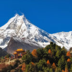
Mount Kanchenjunga is the third highest mountain on earth at 8,586 metres. Its massif straddles the Nepal-India border in the far northeast of Nepal, a full day’s drive or a 45-minute flight east of Kathmandu. Getting here takes effort. The restricted zone permit requirements, the remoteness of the trailhead, the length and physical demands of the circuit, all of these factors conspire to keep the crowds away. They also conspire to make this one of the most authentic and genuinely wild mountain treks remaining anywhere in Asia.
The circuit links both the North Base Camp at Pangpema (5,143 m) and the South Base Camp at Oktang (4,730 m), crossing a series of mountain passes between them; most significantly the Mirgin La, Sele La, Sinion La, and Sinelapche La. Along the way you pass through multi-ethnic villages of Limbu, Rai, and Tibetan Buddhist communities; walk through forests of rhododendron, oak, birch, and pine that hold red pandas and snow leopards; and follow rivers that drain directly from glaciers flanking one of the most dramatic mountain massifs in the world.
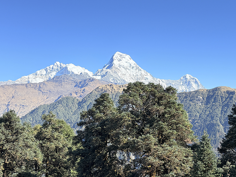
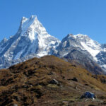
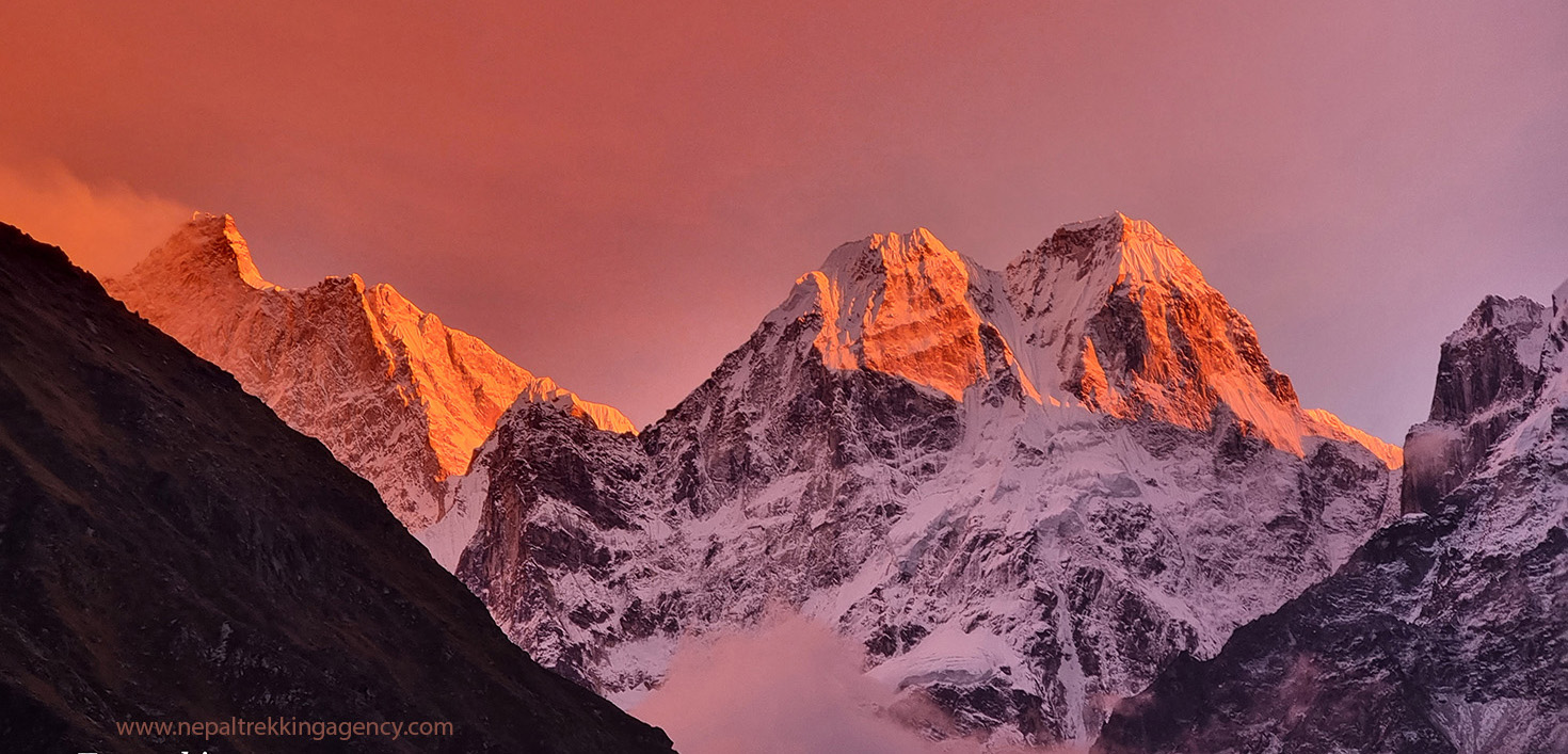
From the north base camp at Pangpema on a clear day, you can see Everest, Lhotse, and Makalu to the west. From the south base camp at Oktang, the colossal southwest face of Kanchenjunga towers directly above you alongside the neighbouring peaks of Kabru, Rathong, and Koktang. Two entirely different perspectives on the same mountain, connected by a circuit that most trekkers will never walk.
This guide covers everything you need to plan it properly.
Kanchenjunga — The Mountain
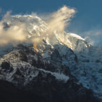
Kanchenjunga (also spelled Kangchenjunga) stands at 8,586 m and sits on the border between Nepal and the Indian state of Sikkim. It is the third highest mountain in the world after Everest and K2, and the highest peak entirely visible from inhabited land, the town of Darjeeling in West Bengal has one of the great mountain views in Asia looking directly at its southern ridges.
The name translates from Tibetan as ‘Five Treasures of the Great Snow’, referring to the five summits that make up the massif. The main peak was first summited by a British expedition in 1955, three years after Everest. In deference to local Sikkimese belief that the summit is sacred, the summit team stopped a few feet short of the actual top, a tradition maintained by most subsequent expeditions.
The mountain’s five summits — Main (8,586 m), West/Yalung Kang (8,505 m), Central (8,482 m), South (8,476 m), and Kangbachen (7,903 m) — create a massif of extraordinary scale. The approach from Nepal reveals the north face from Pangpema and the vast southwest face from Oktang, two of the most impressive mountain panoramas in the Himalaya.
Trek at a Glance
| Duration | 18–21 Days (19 days is most common for the full circuit) |
| Maximum Altitude | 5,143 m / 16,873 ft (Pangpema — North Base Camp) |
| South Base Camp | 4,730 m / 15,518 ft (Oktang viewpoint) |
| Key Passes | Mirgin La (4,645 m), Sele La (4,290 m), Sinion La (4,620 m), Sinelapche La (4,840 m) |
| Trek Start / End | Taplejung / Bhadrapur — reached by flight or drive from Kathmandu |
| Difficulty | Strenuous — prior high-altitude trekking experience required |
| Daily Walking | 6–9 hours; pass-crossing days up to 10 hours |
| Total Distance | Approximately 220–240 km circuit |
| Best Seasons | March–May and October–November only |
| Permits Required | Kanchenjunga Conservation Area Permit + Restricted Area Permit + TIMS |
| Guide Requirement | Legally mandatory — minimum 2 trekkers + licensed guide required |
| Cost (approximate) | USD $1,500–$3,500 depending on group size, operator, and route |
| Nearest Airport | Bhadrapur (domestic flight from Kathmandu, 45 min) or Suketar/Taplejung |
Day-by-Day Itinerary (Standard 19-Day Circuit)
The route below completes the full circuit: Taplejung to North Base Camp (Pangpema), crossing the passes to South Base Camp (Oktang), and returning to Bhadrapur via Taplejung. Row colours indicate the nature of each day.
| Day | Route | Altitude | Walking Time |
| Day 1 | Kathmandu — fly to Bhadrapur, drive to Taplejung (Fungling) | 1,820 m | Flight + 5–6 hr drive |
| Day 2 | Taplejung → Mitlung → Chirwa | 1,270 m | 5–6 hrs |
| Day 3 | Chirwa → Sekathum (Sekathum) | 1,660 m | 5–6 hrs |
| Day 4 | Sekathum → Amjilosa → Gyabla | 2,730 m | 6–7 hrs |
| Day 5 | Gyabla → Ghunsa | 3,410 m | 4–5 hrs |
| Day 6 | Acclimatisation — Ghunsa (rest / explore village) | 3,410 m | Rest / short hike |
| Day 7 | Ghunsa → Kambachen | 4,050 m | 5–6 hrs |
| Day 8 | Acclimatisation — Kambachen (hike toward Jannu viewpoint) | 4,050 m | 3–4 hrs |
| Day 9 | Kambachen → Lhonak | 4,780 m | 5–6 hrs |
| Day 10 | Lhonak → Pangpema (North Base Camp 5,143 m) → Lhonak | 5,143 m then back | 6–7 hrs |
| Day 11 | Lhonak → Ghunsa (retrace) | 3,410 m | 6–7 hrs |
| Day 12 | Ghunsa → High Camp (Sele La approach, 4,100 m) | 4,100 m | 5–6 hrs |
| Day 13 | Cross Sele La, Mirgin La, Sinion La, Sinelapche La → Tseram | 3,870 m overnight | 9–10 hrs |
| Day 14 | Tseram → Ramche → Oktang (South Base Camp 4,730 m) → Ramche | 4,730 m viewpoint | 6–7 hrs |
| Day 15 | Ramche → Tseram → Torangden | 2,995 m | 7–8 hrs |
| Day 16 | Torangden → Yamphudin | 2,080 m | 6–7 hrs |
| Day 17 | Yamphudin → Kharabu → Taplejung | 1,820 m | 6–8 hrs |
| Day 18 | Taplejung → drive to Bhadrapur → fly to Kathmandu | 1,400 m | Drive + flight |
| Day 19 | Buffer / spare day in Kathmandu (recommended) | 1,400 m | — |
Stage-by-Stage Breakdown
Days 1–5: Kathmandu to Ghunsa — The Approach
Day one begins with a 45-minute domestic flight from Kathmandu to Bhadrapur in the eastern Terai, followed by a long road journey north through the hill districts toward Taplejung. The drive takes 5–6 hours on winding mountain roads and passes through a landscape of terraced rice fields, dense forest, and villages increasingly remote from the highway. Some operators split this into two travel days with an overnight stop.
Days two and three follow the Tamur River valley north from Taplejung through villages of Brahmin, Chhetri, Limbu, and Rai communities. The lower trail passes through subtropical vegetation, banana trees, bamboo groves, and rice paddies — a world away from what the upper valley holds. Chirwa and Sekathum are small settlement towns with basic teahouses. The atmosphere is warm and the villages genuinely curious about passing trekkers; this route sees few enough visitors that you won’t feel like part of a convoy.
Day four makes real altitude gain from Sekathum to Gyabla (2,730 m), climbing through increasingly dense rhododendron and oak forest. Gyabla is a Tibetan-influenced settlement with a small gompa and panoramic mountain views opening to the north. Day five continues to Ghunsa (3,410 m), the largest village in the upper Kanchenjunga valley and the effective base for the high section of the trek. Ghunsa is a Tibetan Buddhist community with traditional stone houses, prayer flags, mani walls, and a monastery. The village sits in a wide valley with the first serious mountain views — Jannu (Kumbhakarna, 7,711 m) is visible to the west, one of the most dramatically shaped peaks in the entire Himalaya.
Day 6: Acclimatisation at Ghunsa (3,410 m)
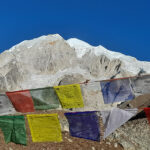
A full rest day here is essential and non-negotiable. The jump from lower valleys to Ghunsa at 3,410 m is significant, and the days ahead push considerably higher. Use the day for gentle walks around the village and monastery, plenty of hydration, and a solid night’s sleep. The monastery at Ghunsa is worth a proper visit — monks conduct morning and evening ceremonies, and the painted interior murals are among the best Buddhist art accessible on any Nepal trek.
Days 7–9: Ghunsa to Lhonak — The High Valley
Day seven climbs from Ghunsa to Kambachen (4,050 m), a small settlement of stone and timber lodges above the treeline in a wide glacial valley. The trail passes through thinning juniper and rhododendron scrub, and the scale of the terrain changes dramatically — you’re now in the high alpine zone, with glaciated peaks framing the horizon in every direction. Jannu’s north face looms to the southwest; a mountain of extraordinary presence even by Himalayan standards.
Day eight is a second acclimatisation rest at Kambachen. The standard exploration hike heads toward the ridge above the village for views of Jannu’s northern approaches and the icefalls feeding the Kanchenjunga Glacier. This day hike helps push the acclimatisation ceiling without committing to the big altitude gain ahead. Rest, eat well, and drink water.
Day nine climbs to Lhonak at 4,780 m. The trail follows the valley floor through increasingly raw terrain — loose moraine, glacial streams, boulder fields — as the valley narrows and the peaks close in. Accommodation at Lhonak is extremely basic by any standard: simple wooden bunkrooms with no hot water, limited food options, and temperatures that drop well below freezing overnight. Bring a sleeping bag rated for the cold. The location, however, is something else entirely. Kanchenjunga’s north face fills the view ahead.
Base Camp Day 1 — Pangpema: North Base Camp (5,143 m)
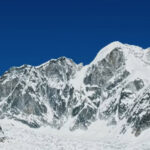
Rise before dawn. The trail from Lhonak follows the lateral moraine of the Kanchenjunga Glacier for approximately three hours, climbing gradually over rocky, occasionally slippery terrain to Pangpema at 5,143 m. This is the North Base Camp of Kanchenjunga — a high, windswept plateau ringed by an extraordinary concentration of peaks.
The view from Pangpema is genuinely staggering. Kanchenjunga Main (8,586 m) dominates straight ahead, its north face rising in a colossal wall above the glacier. Wedge Peak, Tent Peak, and The Twins flank the glacier below the summit. To the west, on a clear day, Everest (8,849 m), Lhotse (8,516 m), and Makalu (8,481 m) are all visible — four of the world’s five highest mountains visible from a single viewpoint. Take the time to absorb this. Walk out to the moraine ridgeline for different angles. Photograph everything. Then begin the return to Lhonak; do not attempt to overnight at Pangpema without specific medical guidance and full cold-weather equipment.
Day 11: Lhonak to Ghunsa — Descent and Preparation
The descent retraces the approach through Kambachen to Ghunsa. What required two careful days of ascent takes one long afternoon going down. The vegetation returns progressively — juniper first, then rhododendron, then mixed forest — and the temperature rises noticeably with each 500 metres of descent. Back in Ghunsa for the night. The passes ahead require a full night’s rest here before the High Camp approach.
Day 12: Ghunsa to High Camp (Sele La Approach, 4,100 m)
Leaving Ghunsa, the trail climbs southeast through dense forest on a rocky, occasionally steep path toward the high camp below the first pass. The terrain changes from the broad northern valley floor to the more enclosed, forested flanks of the southern ridgeline. High Camp at approximately 4,100 m sits in a sheltered position with small wooden lodges, a nearby lake, and good views of Makalu to the northwest on clear days. An early night here is important: the following day is the hardest of the entire trek.
Pass Day — Sele La, Mirgin La, Sinion La, Sinelapche La: High Camp to Tseram
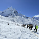
This is the defining day of the Kanchenjunga Circuit, and one of the most demanding single days of walking available on any standard Nepal trek. You will cross four distinct mountain passes, each with its own ascent and descent, totalling approximately 850 metres of upward gain and over 1,100 metres of descent in a single day. Start before sunrise. Carry lunch, snacks, and all water you need — there are no teahouses between High Camp and Tseram.
The sequence: Sele La (4,290 m) is the first pass, reached after a steep climb from camp with sweeping views of the Kanchenjunga massif. From Sele La, the trail contours and climbs again to Mirgin La (4,645 m) — the highest of the four passes and the psychological pivot of the circuit. At the top of Mirgin La you are crossing from the north side to the south side of the Kanchenjunga range. Behind you lies the Jannu and Kanchenjunga north face panorama; ahead, not yet visible, is the Yalung valley. Views from here include Makalu, Chamlang, Baruntse, and on exceptional days, a glimpse of Everest.
Pressing on, the trail climbs once more to Sinion La (4,620 m), then makes a final ascent to Sinelapche La (4,840 m) — the highest pass of the day. From the top of Sinelapche La, the enormous descent begins: 1,000 metres down through rocky terrain, past glacial lakes, through scrubby forests to Tseram (3,870 m). This final descent tests legs, knees, and resolve. Trekking poles are essential. Arrive at Tseram at dusk, or earlier if you started before dawn. Tonight’s dinner and sleep will feel thoroughly earned.
Base Camp Day 2 — Oktang: South Base Camp (4,730 m)
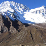
The south base camp day is structured differently from the north. From Tseram, the trail climbs to Ramche (4,580 m) through forest that gradually opens into the ablation valley alongside the Yalung Glacier. The Yalung Glacier is one of the largest in Nepal, fed by the enormous southwest face of Kanchenjunga; walking alongside its snout and lower flanks gives a sense of scale that photographs simply don’t convey.
From Ramche the trail continues to Oktang (Okhordung) at 4,730 m — the viewpoint known as South Base Camp. The view here is entirely different from Pangpema. The southwest face of Kanchenjunga rises almost vertically above, flanked by Kabru (7,412 m), Rathong (6,679 m), and Koktang (6,147 m) to the east. The mountain from this angle is considered by many Himalayan photographers and climbers to be the most beautiful face of any peak in the range — broader, more sculptural, and more complex than the north face. Spend as long as conditions allow. Return to Ramche for the night.
Days 15–18: The Descent — Tseram to Bhadrapur
The walk out from Tseram follows the southern trail through the lower Yalung valley to Torangden and then to Yamphudin (2,080 m), a large Limbu and Rai village with good teahouses and a warm welcome. The vegetation transitions back through alpine meadow, mixed forest, and eventually subtropical jungle over two days. This section of the trail is botanically rich — orchids, tree ferns, mosses, and bird life increase rapidly below 3,000 m.
Day seventeen reaches Taplejung via Kharabu, completing the circuit. Day eighteen is the return to Bhadrapur by road and then the domestic flight back to Kathmandu. The road journey passes through the eastern hills with views of the Kanchenjunga massif from the south — a last look at the mountain from a completely different perspective before the plains of the Terai appear and the journey ends.
Top Highlights of the Trek
- Pangpema (5,143 m) — North Base Camp of Kanchenjunga, one of the highest and most remote trekking viewpoints in Nepal, with Everest, Lhotse, and Makalu visible on clear days
- Oktang (4,730 m) — South Base Camp viewpoint overlooking the vast southwest face of Kanchenjunga and the Yalung Glacier alongside Kabru and Rathong
- Four-pass crossing day — Sele La, Mirgin La, Sinion La, and Sinelapche La in a single 9–10 hour stage: the most demanding single day on any standard Nepal circuit
- Jannu / Kumbhakarna (7,711 m) — one of the most dramatically shaped peaks in the Himalaya, visible from Ghunsa and Kambachen at close range
- Kanchenjunga Conservation Area — a UNESCO heritage buffer zone with some of the highest biodiversity of any protected area in Nepal
- Red pandas — the conservation area holds one of Nepal’s healthiest red panda populations; sightings are possible in the rhododendron forests between Gyabla and Ghunsa
- Snow leopards — present throughout the upper valley; rarely seen but their pugmarks and kill sites are occasionally spotted above Kambachen
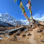
- Multi-ethnic villages — Limbu, Rai, Brahmin, Chhetri, and Tibetan Buddhist communities in the lower and upper valleys; extraordinary cultural diversity in a single trek
- Ghunsa monastery — a working Tibetan Buddhist monastery with active monks, traditional murals, and a morning puja ceremony accessible to respectful visitors
- The Tamur River valley — one of the most scenically varied river corridors in Nepal, dropping from glacial headwaters through subtropical forest to the plains
- True wilderness solitude — fewer than 1,000 trekkers annually versus 300,000+ on the Annapurna Circuit; long stretches of trail with no other trekking parties in sight
Permits, Regulations, and Legal Requirements
The Kanchenjunga region is a designated Restricted Area under Nepal’s trekking regulations. This status carries several requirements that apply to all foreign trekkers and are strictly enforced at checkpoints throughout the route.
Mandatory requirements
- Minimum group size: 2 trekkers. Solo trekking is not permitted in the Kanchenjunga Restricted Area — this is a legal requirement, not a guideline. Single travellers must join a group or hire a second person to meet the two-person minimum.
- Licensed guide: Mandatory. You must be accompanied by a certified Nepali trekking guide at all times in the restricted area. No exceptions.
- Kanchenjunga Conservation Area Permit (KCAP) — approx. NPR 3,000 (~USD $22). Covers entry to the Kanchenjunga Conservation Area.
- Restricted Area Permit (RAP) — approx. USD $20 per week (USD $10 for each additional week). Issued by the Department of Immigration in Kathmandu. Required specifically for the restricted zone portion of the trek.
- TIMS Card (Trekkers’ Information Management System) — approx. NPR 2,000 (~USD $15). Required for all trekking routes in Nepal.
All permits must be arranged in Kathmandu before departure. Your trekking operator will handle this. Carry all original permits at all times — checkpoints are present at Taplejung, Gyabla, Ghunsa, and multiple points on the southern circuit. Photocopies are not accepted.
Best Time to Go
- October to November (autumn): The optimal window. Post-monsoon clarity delivers the sharpest mountain views. Temperatures are cold at altitude but manageable with proper equipment. October is preferable to November — by late November temperatures at Lhonak and High Camp drop severely, and the passes can accumulate early-season snow. Book flights to Bhadrapur and accommodation in Taplejung well in advance.
- March to May (spring): Equally excellent for visibility, with the added spectacle of rhododendron forests in full bloom throughout the lower and mid-trail sections. Kanchenjunga’s lower elevations are botanically extraordinary in spring — the rhododendron forests between Gyabla and Ghunsa are among the finest in Nepal. The Kanchenjunga Conservation Area receives almost no spring traffic, making this the quietest and potentially most rewarding season for this route.
- December to February (winter): Not recommended. The passes (particularly the four-pass crossing day) accumulate deep snow, High Camp and Lhonak become genuinely dangerous without cold-weather mountaineering equipment, and road access to Taplejung can be disrupted by snowfall at higher elevations. Experienced winter trekkers with appropriate kit can attempt the route, but this requires prior consultation with a local operator.
- June to September (monsoon): Do not attempt. The lower trail sections are notorious for leeches and deep mud, landslides threaten the approach roads, the passes become extremely hazardous, and the mountain views for which the trek exists are completely obscured. Bhadrapur flights are frequently cancelled due to monsoon weather.
Difficulty and Fitness
The Kanchenjunga Circuit is rated strenuous. The difficulty stems from several compounding factors rather than any single technical challenge.
- Duration: 18–21 consecutive days of significant daily hiking is a significant endurance commitment. Accumulated fatigue becomes a real factor by Day 12 onwards, precisely when the hardest day of the trek arrives.
- Remoteness: Once above Ghunsa, there is no easy exit. Helicopter evacuations are possible but expensive and weather-dependent. The sense of commitment is genuine.
- The four-pass crossing: Day 13 is a 9–10 hour day crossing four mountain passes between 4,290 m and 4,840 m. This is the crux of the circuit and requires full acclimatisation, a very early start, good fitness, and an experienced guide who knows the route.
- Altitude at base camps: Pangpema at 5,143 m is higher than Everest Base Camp. Multiple nights above 4,000 m and a peak day above 5,000 m demand serious respect for altitude acclimatisation.
- Trail conditions: Sections of the circuit — particularly above Kambachen and on the pass-crossing day — involve loose moraine, glacial terrain, landslide-prone slopes, and unmarked paths. The trail is not maintained to the standard of the Annapurna or EBC routes.
Prior experience strongly recommended: at least one previous multi-day trek to 4,000+ m. Trekkers who have completed the Everest Base Camp, Annapurna Circuit, or Manaslu Circuit routes will find the physical demands of Kanchenjunga familiar, though the remoteness adds a different dimension.
Physical preparation: 3–5 months of dedicated cardiovascular and endurance training. Long hiking days with a loaded pack are the most relevant preparation. Include leg-strength work (squats, step-ups, lunges) for the sustained descents. Arrive in Kathmandu at least one day before departure to manage permits and any logistics, and consider a day hike in the Kathmandu hills to check your kit.
Accommodation
Teahouses cover the full circuit, though the quality varies enormously between the lower valleys and the high sections above Ghunsa.
- Taplejung and lower valley villages (Chirwa, Sekathum): Simple but clean teahouses with private rooms, local food, and basic facilities. The warmth of the hosts in the lower Limbu and Rai villages is a highlight of the early trail days.
- Gyabla and Ghunsa (2,730–3,410 m): Better facilities. Ghunsa has the best range of accommodation on the circuit — private rooms, some lodges with solar-heated showers, and a choice of menus. Stock up here on any snacks, extra layers, or batteries before heading higher.
- Kambachen (4,050 m): Basic but functional teahouses with private rooms. Good for the altitude. Heating is limited — a sleeping bag rated to at least -10°C is needed from here.
- Lhonak (4,780 m): Extremely basic wooden bunkrooms. No private rooms. Cold, dark, and minimal. The experience of being here, however, is extraordinary. This is about as remote as it gets on a standard Nepal trek.
- Tseram and Ramche (3,870–4,580 m): Small stone lodges on the southern circuit. Tseram has several options; Ramche has fewer. Both are functional and adequately warm. The food improves noticeably on the southern side — vegetables from lower valleys are fresher.
- Yamphudin and lower southern trail: Comfortable teahouses in genuinely beautiful lower valley settings. These final nights feel like a luxurious return to civilisation after the high circuit.
Meals throughout follow the Nepali teahouse standard — dal bhat, noodles, pasta, fried rice, eggs, soups. Dal bhat (unlimited refills, the best endurance fuel on the trail) is available at almost every teahouse. Bring sufficient Nepali Rupee cash for the entire circuit — the last ATM is in Taplejung. There are no ATMs, card machines, or reliable mobile payment options above town level on this route.
How Much Does It Cost?
| Category | Approximate Cost (USD) |
| Budget (local guide hire + independent) | $900–$1,400 |
| Mid-range operator package (19 days, full service) | $1,500–$2,500 |
| Fully inclusive small group (international operator) | $2,500–$3,500+ |
| Domestic flight: Kathmandu–Bhadrapur return | $120–$180 return |
| Road transfer: Bhadrapur–Taplejung (one way) | $20–$50 (shared jeep / private) |
| All permits (RAP + KCAP + TIMS) | ~$57 + RAP fees per week |
| Tipping (guide + porter/s) | $12–$20 per day total |
The restricted area permit (RAP) is calculated per week: USD $20 for the first week, USD $10 for each additional week. For a 19-day circuit, budget approximately USD $40–$50 for the RAP alone in addition to the KCAP and TIMS fees.
What to Pack
Clothing
- Merino wool base layers, top and bottom — merino’s odour resistance matters more on a 19-day circuit than on shorter treks
- Heavyweight fleece mid-layer and a down jacket rated to -15°C minimum — nights at Lhonak and High Camp can reach -20°C
- Lightweight down layer for teahouse evenings above 4,000 m
- Waterproof hard-shell jacket and trousers — rain and wind protection on the passes is essential
- Warm trekking trousers — zip-off convertibles are impractical above 4,000 m
- Expedition-weight gloves plus thin liner gloves, warm hat, balaclava, neck gaiter
- Waterproof, well-broken-in trekking boots with ankle support
- Gaiters — for snow and loose scree on the pass-crossing day
- Camp shoes or sandals for teahouse evenings
Gear and Equipment
- Trekking poles — non-negotiable for the 1,000+ metre descent off the passes
- Sleeping bag rated to -15°C or colder — mandatory from Kambachen upward
- Sleeping bag liner for additional warmth and teahouse hygiene
- Daypack (25–35 litres) — your porter carries the main duffel bag
- Headlamp with spare batteries — dawn starts on the pass day require pre-sunrise navigation on unmarked terrain
- UV400 mountain sunglasses — glacier and snow glare at altitude is severe
- High-SPF sunscreen (factor 50+) and protective lip balm
- Insulated water bottle (1.5–2 litres) — water freezes in standard bottles above 4,500 m overnight
- Water purification tablets and a UV Steripen — water sources above Ghunsa must be treated
- Pulse oximeter — essential for monitoring blood oxygen on multi-night stays above 4,000 m
- Personal first aid kit: Ibuprofen, Diamox (prescription required), antihistamine, blister pads, re-hydration salts, sterile dressings, antiseptic
- Portable power bank, minimum 20,000 mAh — electricity is unreliable above Ghunsa and absent at Lhonak
- Sufficient Nepali Rupee cash for the entire 19 days — no ATMs beyond Taplejung
- A lightweight repair kit for boots (sole adhesive) and clothing
Health, Safety, and Altitude Management
Altitude Sickness
AMS risk on the Kanchenjunga Circuit is significant. Pangpema at 5,143 m is above Everest Base Camp, and the pass-crossing day involves sustained effort at between 4,300 m and 4,840 m after multiple nights already at altitude. The acclimatisation days built into the itinerary at Ghunsa (3,410 m) and Kambachen (4,050 m) are essential — do not skip them regardless of how you feel.
- Standard AMS symptoms: persistent headache, nausea, loss of appetite, dizziness, fatigue, disrupted sleep. Manageable with rest and hydration at the same altitude.
- Serious altitude illness (HAPE/HACE): breathlessness at rest, crackling cough, loss of coordination, confusion — requires immediate descent and emergency medical care.
- The absolute rule: if symptoms worsen, descend. Immediately. There is no safe ‘wait and see’ strategy above 4,000 m if condition deteriorates.
- Drink 3–4 litres of water daily. Dehydration compounds altitude sickness significantly.
- Diamox (Acetazolamide) 125–250 mg twice daily assists acclimatisation. Consult a GP before departure and start 24 hours before ascending above 3,000 m.
- Carry a pulse oximeter and check SpO2 readings morning and evening above 4,000 m. Below 75% SpO2 with worsening symptoms warrants immediate attention.
Medical Facilities and Evacuation
There are no medical facilities above Taplejung. The nearest hospital with relevant capability is in Dharan or Biratnagar (eastern Nepal), several hours from Taplejung by road. Emergency helicopter evacuation is the realistic option for serious illness or injury above Ghunsa.
- Travel insurance covering high-altitude trekking to 6,000 m and helicopter evacuation is mandatory. Rescue from Lhonak or the pass-crossing area costs USD $5,000–$10,000 without coverage.
- Helicopter rescue in the Kanchenjunga region is weather-dependent and may not be possible for 24–48 hours during poor conditions. This is a genuine factor — not a theoretical risk.
- Himalayan Rescue Association (HRA): +977-1-4440066. Your guide should carry this number and know the nearest helicopter landing points on the route.
Leeches and Wildlife
The lower trail between Taplejung and Gyabla is leech-infested during the monsoon season and to a lesser extent in the post-monsoon early October period. If trekking in October, wear long socks, apply salt or DEET to boot tops, and check regularly. Leeches are harmless but unpleasant and persistent. Above Ghunsa the trail is leech-free.
Bears (Himalayan black bear and sun bear) are present in the lower forest sections. Make noise while walking in dense vegetation and your guide will manage this. Snow leopard and red panda sightings, while rare, have been reported throughout the conservation area.
Guide, Porter, and Team
A licensed guide is legally mandatory on this route — not optional, not suggested, mandatory. Beyond the legal requirement, the practical case is overwhelming: the trail above Ghunsa is poorly marked in sections, the four-pass crossing day involves complex route-finding on rocky terrain, and the remoteness of the upper circuit means any navigation error could have serious consequences.
Beyond safety and navigation, a good guide on the Kanchenjunga Circuit is a cultural interpreter. The ethnic diversity of the route — Limbu, Rai, Tibetan Buddhist communities — is one of its great assets. A guide from the region provides context, manages teahouse relations, and helps you understand what you’re seeing in a way that independent trekking cannot.
Porter employment is important here. Carry what you reasonably can in a daypack, let your porter carry the main load (max 25–30 kg), and ensure they have adequate clothing for the altitudes they will reach — up to Ghunsa at minimum, and High Camp if they accompany you there. Pay fair wages, tip generously, and treat them as the professionals they are. Budget USD $5–8 per day per porter in addition to the tipping allocation above.
Frequently Asked Questions
Can I trek Kanchenjunga independently, without a guide?
No. The Kanchenjunga region is a Restricted Area under Nepal government regulations, and trekking without a licensed guide is illegal. The minimum requirement is two trekkers and a licensed guide. Solo travellers must connect with another trekker or arrange a second person through their operator to meet the group minimum. This regulation is actively enforced at multiple checkpoints on the route.
What is the best direction to trek the circuit?
The standard direction — north base camp first (Pangpema), then crossing the passes to south base camp (Oktang) — is preferred by most operators for acclimatisation sequencing. The north side offers a more gradual altitude gain through Ghunsa, Kambachen, and Lhonak before the 5,143 m Pangpema high point, then the demanding four-pass day follows when you’re best acclimatised. The reverse direction is possible but generally considered less optimal for acclimatisation management.
How does the Kanchenjunga Circuit compare to Everest Base Camp?
They share a difficulty rating but differ fundamentally in character. EBC takes 12–16 days on a heavily trafficked, well-serviced trail. Kanchenjunga takes 18–21 days on a trail that sees fewer than 1,000 trekkers per year, requires restricted area permits, visits two base camps, crosses four mountain passes in a single day, and pushes into genuine wilderness terrain. The maximum altitude is comparable (5,143 m vs 5,364 m at EBC), but the overall challenge of Kanchenjunga — duration, remoteness, pass-crossing difficulty — is greater. If EBC is your baseline, Kanchenjunga is the next serious step up.
What wildlife can I expect to see?
The Kanchenjunga Conservation Area is one of Nepal’s most biodiverse protected zones. Red pandas inhabit the rhododendron and bamboo forests between roughly 2,500 m and 4,000 m and are more likely to be spotted here than anywhere else in Nepal — early morning walks between Gyabla and Ghunsa offer the best chance. Snow leopards are present throughout the upper valley above Ghunsa but sightings are rare and considered exceptional. Himalayan tahr, musk deer, Himalayan black bear, and a remarkable variety of bird life including satyr tragopan, blood pheasant, and Himalayan monal pheasant are encountered throughout the route.
Is there mobile phone coverage on the route?
Sporadic Ncell and NTC coverage exists in the lower valleys and in Ghunsa. Above Ghunsa, coverage is effectively absent until descent to the southern valley villages. Satellite communicators (Garmin inReach, SPOT) are recommended for trekkers who want emergency communication capability throughout the circuit. Your guide will typically have a satellite phone or a local communication arrangement for emergencies.
What is the road and flight access like?
The standard approach is a domestic flight from Kathmandu to Bhadrapur (45 minutes) followed by a road journey to Taplejung (5–6 hours by jeep). Some operators fly directly to Suketar (Taplejung’s small airfield) when conditions allow, cutting a day off the approach. Direct Suketar flights are unreliable and weather-dependent — Bhadrapur is the more dependable entry point. Factor a buffer day into your schedule for the return journey.
Final Word
There is a version of Nepal trekking that involves following a well-worn trail shared with thousands of other trekkers, sleeping in comfortable lodges, and ordering from a menu that includes yak cheese pizza and apple pie. That version is excellent. But it is a different thing from what the Kanchenjunga Circuit offers.
Kanchenjunga is Nepal’s most remote grand circuit. The mountain itself — third highest on earth, politically significant, sacred to the people who live in its shadow, and visited by fewer trekkers in a year than Everest Base Camp receives in a week — commands a different kind of attention than a trek in a busy corridor. The villages you pass through haven’t adjusted their rhythms to accommodate trekking tourism. The forests hold animals that have space to exist. The passes are serious enough that crossing them feels like an accomplishment rather than a formality.
It takes more planning than the standard routes. The permit process is more involved, the logistics are longer, and the trail demands real preparation. But for trekkers who are ready for it, the Kanchenjunga Circuit delivers an experience that genuinely cannot be replicated on any busier route in Nepal.
The crowds go west. Go east.
Recent Posts