Tsho Rolpa Lake Trek: Nepal’s Most Underrated Glacial Route
Most people researching Nepal treks land on Everest Base Camp or Annapurna Circuit within five minutes. Understandable. Both are excellent. Both are also crowded enough that you’ll spend portions of the trail in a slow-moving queue of trekkers who booked the same itinerary from the same agency.
Tsho Rolpa doesn’t have that problem.
Sitting at 4,580 meters inside the Gaurishankar Conservation Area, Nepal’s deepest glacial lake sits at the end of a route that sees a fraction of the foot traffic of the major corridors. The Rolwaling Valley is geographically hemmed in, culturally distinct, and largely left alone by the trekking mainstream. That’s exactly what makes it worth going.
What the Trek Actually Delivers
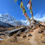
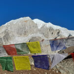
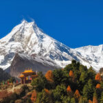
The trail runs through Tamang settlements that haven’t restructured themselves around tourism. Simi Gaun, Bedding, and Na Village are working communities, not rest stops. The Tamang-Buddhist culture here shows up in the physical landscape: chortens at trail junctions, mane walls you pass on the left, prayer flags strung between ridgelines that have probably held them for decades.
Bigu Gompa, home to a community of Buddhist nuns, sits along the route. It’s not a tourist attraction. It functions.
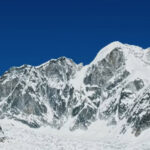
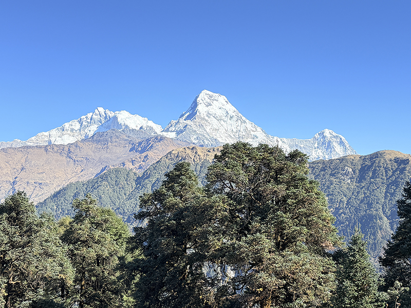
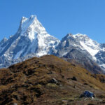
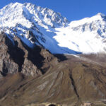
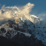
From Tsho Rolpa itself and the vantage at Dudh Kunda, the peak lineup includes Gaurishankar at 7,145m, Melungtse at 7,181m, Dorje Lhakpa at 6,966m. On clear days, specific faces of Everest are visible. These aren’t distant smudges on the horizon. The Rolwaling range puts you close enough that the scale registers properly.
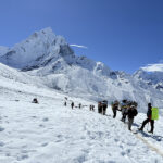
The terrain between the trailhead and the lake moves through rhododendron forest, river-cut gorges alongside the Rolwaling River, suspension bridges over drops that make you pay attention, and alpine meadows that open up above treeline. Waterfalls throughout. The trail is stone-paved for most of its length, well-marked, without confusing branch points.
Trek Highlights
- Direct sightlines to Gaurishankar (7,145m), Melungtse (7,181m), Dorje Lhakpa (6,966m), and partial Everest views on clear days
- Tsho Rolpa Glacial Lake at 4,580m, Nepal’s deepest glacial lake
- Tamang villages of Simi Gaun, Bedding, and Na, largely untouched by commercial trekking
- Rolwaling River trail, maintained, quiet, scenic without trying to be
- Bigu Gompa and active Buddhist practice throughout the valley
- Dense rhododendron forest, truss bridges, waterfalls, alpine vegetation
- Minimal trekking groups, no queues, no teahouse dining rooms packed to capacity
Difficulty: Honest Assessment
Moderate. That’s the accurate grade and it holds for most of the route.
The trail gains 700 to 800 meters per day in a controlled, gradual profile. It starts at Chhet Chhet at 1,398 meters. The stone-paved surface handles most weather conditions without becoming treacherous. There are no route-finding problems since the main trail doesn’t split into confusing alternatives.
The exception is the final ascent to Tsho Rolpa. It’s steep, it’s tiring, and at that altitude your lungs will register the difference. Not technical, but the kind of climb that requires you to have done the work beforehand.
Acclimatization issues are minimal on this route. The gradual altitude gain and the presence of dense vegetation providing good oxygen levels up through Thandding and Bedding make altitude sickness unlikely for trekkers who aren’t rushing. No dedicated acclimatization days are built into the standard itinerary.
One month of regular cardio training before the trek is the standard recommendation. Not because the trail will break you if you skip it, but because the final section to the lake feels significantly different on legs that have been prepared versus legs that haven’t.
Best Time to Trek Tsho Rolpa
Spring (March to May) is the primary season. Rhododendrons are in bloom from March. April opens the valley into full green. May delivers the clearest mountain views before pre-monsoon haze builds. Early spring occasionally freezes the surface of Tsho Rolpa Lake, which is worth timing for if you can.
Autumn (September to November) runs close behind. Post-monsoon clarity strips the haze off the mountains completely. The Rolwaling River is lower, trails are dry, and the Nepali festival calendar runs through this period, so villages are active, decorated, and considerably more lively than the off-season baseline.
Monsoon and winter are possible for experienced trekkers with the right gear, but neither delivers the trail conditions or visibility that justify choosing them over the peak windows.
Accommodation Along the Route
Tea houses run the length of the route, managed almost entirely by local Tamang families. Several lodge owners are themselves experienced high-altitude trekkers, with Everest summits among them, which gives the hospitality along this route a particular character. These aren’t people running lodges because it’s the only economic option. Many genuinely know the mountains.
Overnight stops at Simi Gaun, Dongang, Kyalje, Bedding, and Na all have lodge accommodation. Standard setup is private twin rooms with clean mattresses, blankets, pillowcases, and electricity. Shared bathrooms with running water and hand wash facilities. No attached bathrooms on this route, but the shared facilities are maintained.
The dining room is the warm room. Same principle as every other Himalayan tea house route: the communal space has the stove, the bedrooms don’t. Bring a sleeping bag.
Food on the Route
The menu gets simpler as the trail gains altitude, which is standard for any less-traveled Himalayan route. Below Simi Gaun, options are limited. Above it, the tea house kitchens produce proper breakfasts: porridge, noodles, soup, pancakes, eggs prepared multiple ways, potato dishes, roti.
Lunch defaults to dal bhat tarkari, which is the right call. Rice, lentil soup, fresh vegetables including spinach, mushroom, radish, and potato, finished with yak ghee and fermented pickle. Dal bhat refills. Nothing else on the menu competes at altitude for sustained energy.
Dinner mirrors the lunch menu closely. Dhindo (cornmeal porridge) with vegetable soup is specific to this region and worth ordering at least once. Thukpa works well in the evenings when temperatures drop. The kitchen at most lodges is producing food from local supply chains, not trucking in ingredients from Kathmandu, so freshness is generally not the concern it might be on more remote routes.
Tea houses on the Tsho Rolpa route provide free hot water, which is genuinely useful and not standard practice on the commercial routes.
Connectivity
Don’t plan your trip around staying connected. It’s not that kind of trek.
Nepal Telecom 3G signal is available at specific points: Simi Gaun, Kyalje, Thandding Kharka, and Bedding. Dongang has a satellite phone at the tea house. Wi-Fi doesn’t exist on this route. Between signal points, you’re offline.
This is not a problem. It’s the point. The Rolwaling Valley is the version of Nepal that people describe when they say they went to Nepal and found something they weren’t expecting. That experience has a direct relationship with not being able to check anything.
Trek Summary
Duration: 7 days
Max Altitude: 4,580m (Tsho Rolpa Lake)
Difficulty: Moderate
Starting Point: Chhet Chhet (1,398m)
Conservation Area: Gaurishankar Conservation Area
Best Seasons: Spring (March-May), Autumn (September-November)
Accommodation: Tea house lodges managed by local Tamang families
Acclimatization Days Required: None
Key Peaks Visible: Gaurishankar (7,145m), Melungtse (7,181m), Dorje Lhakpa (6,966m), Everest (8,848m, partial views)
Recent Posts